November 29, 2010

Department of Pipe Dreams: Highway 680 Bus Rapid Transit, Pt I

Making fantasy transit maps is a favored pastime of at least a few urban planning bloggers, but I must confess this pipe dream was dreamed well before I read about Transbay's dream Bus Rapid Transit plans, mega MTA, or a Boston with an MBTA urban ring. Goes to show that fantasy is a standard, and seductive, business.

In this post I'll give a general overview of why a BRT line linking West Dublin/Pleasanton BART and Walnut Creek BART in the Highway 680 right of way would be a good idea, if wishes were horses. In Part II, I'll go into more detail about Bus Rapid Transit particulars, individual station locations and treatments, what kind of feeder bus networks would be needed, and what incentives and enhancements could boost hypothetical ridership.

The Pitch

Interstate 680, north of 580 and south of 24, is clogged with traffic, especially during commuter rush hour. Large sections of it are built out, making expansion difficult. The Walnut Creek BART Station in the north and Dublin/Pleasanton Station in the south take commuters into Oakland and San Francisco, but full parking lots and underused buses limit station capacity. The area in between the stations is a transit desert, served only by a scattering of County Connection bus lines. These bus lines already use the two BART stations as convenient route termini, but rely on the anonymous, tucked away, San Ramon Transit Center for their origin. Housing developments and sprawl continue at the edges of existing development, further impacting 680. Cities and towns surround 680, yet the corridor lacks density or sheer population to justify a BART connection. (BART is already in trouble for expensive boondoggles, landing on the wrong side of violent and financial civil rights disputes, and being politically obligated to build out to inefficient locations because those locations happen to contribute revenue to it.) 680 is the principal artery for the region, a necessity to get to either BART station, anywhere else in the Bay Area, and many local trips.


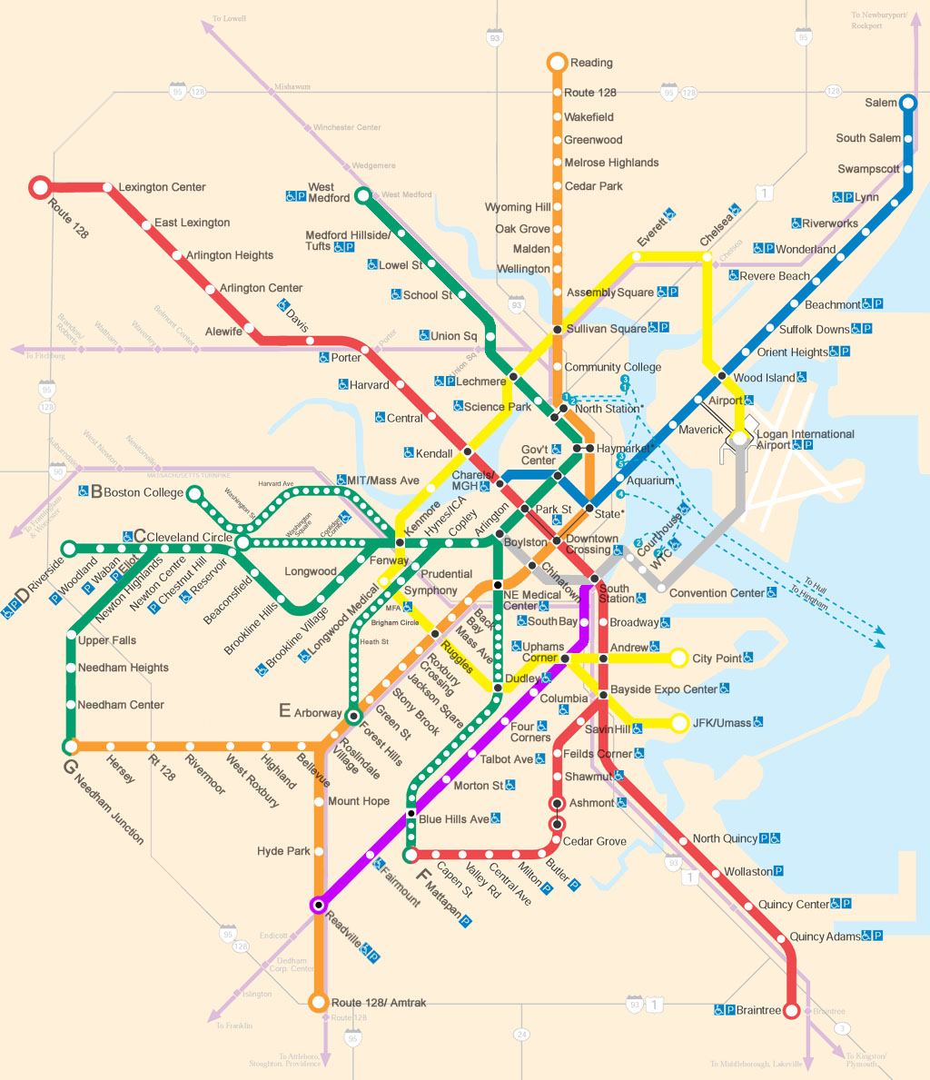
BRT on 680 would fill in the gap between D/P and Walnut Creek

Note how developments are concentrated around 680, but spreading eastward in San Ramon/Danville. BART Stations are located where 680 and 24 intersect in Walnut Creek, and 680 and 580 intersect in Dublin.


The Overview

Bus Rapid Transit for the 680 corridor would link the under-construction West Dublin/Pleasanton BART Station to the Walnut Creek Station. It would have its own dedicated right of way for the duration of the route, off board fare collection, and triple-door low floor buses (or raised platforms) to facilitate minimal holding times at stations. To cater to business commuters, the buses could offer wireless internet. Stations will be built around intersections where 680 crosses over or under major suburban arterials.

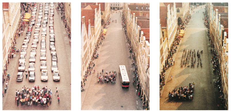
Like this, Transmilenio style (Bogotá, Colombia)

Investing in the highway right of way would centralize and reorient bus operations into a main trunk route fed by feeder buses. Feeder buses would run along the high-volume arterials that traverse the region--streets like Crow Canyon, Bollinger Canyon, Ygnacio Valley, and Stone Valley Roads. Users would need to get to the nearest arterial, and from there, using the system would intuitively mimic how they already move around the region: accessing and exiting 680.

While BRT could certainly be used for a variety of daily trips, its largest value-add will be for commuters traveling out to Oakland and San Francisco, or commuters coming in to the office parks in San Ramon and Pleasanton. BRT's guaranteed traffic-free ride to BART will reduce incentive to both a) drive to BART, and b) drive to the final workplace destination, taking cars off the road and diminishing rush hour traffic.

Stay tuned for the list of stations and locations of feeder routes!

November 26, 2010

Transportation Planning, Teaching, and the Importance of Objectives

Last Thursday I attended one of the West Contra Costa Transportation Advisory Council's Technical Advisory Committee meetings. Add that all up, and you get a WCCTAC TAC, pronounced "wicktactac." Which is exactly what they call it, beautifully enough.

Anyway, I took the 72R from El Cerrito Del Norte, and got off just north of Church and San Pablo Ave, where the City of San Pablo offices are. The complex has a low profile from the street, but opens up onto a pleasantly lush Spanish-style courtyard. I found the room with help from a friendly janitor, introduced myself to John Rudolf, my contact from the Berkeley Planning open house, and took a seat for the meeting.

A representative from Caltrans opened the meeting by reviewing implementation plans for installing traffic cameras along the Interstate 80 corridor. The closed circuit cameras would be placed at intersections between on ramps and local streets to monitor traffic before it gets to the highway. 23 cameras already dot local streets along I-80; this project would add 54 more to monitor local traffic at specific highway access points.

Everything seemed pretty open and shut: Caltrans was improving infrastructure to enable it to better monitor local conditions at access points to the critical highway in the area. There were packets of information with lists of proposed intersections, maps, and bullet-pointed lists of official things. From what the Caltrans rep reported, I gathered that Caltrans had approached cities about potential CCTV camera locations, and had asked the relevant contacts if their respective cities would like cameras where indicated. The response: yes. So Caltrans moved forward with the project, but failed to adequately communicate the objective.

The evidence I have to substantiate the lack of a communicated objective is only what I witnessed at the meeting. Christina Atienza, Executive Director of WCCTAC, asked whether any data existed re how often the 23 existing CCTV cameras were used. There wasn't, yet. A representative from another city asked what the new cameras would be used for. To identify traffic conditions on local streets was one answer, but no one could describe what functionality this would add, especially since no one was sure whether the existing cameras were being used. Would Caltrans respond to camera-ID'd situations? How? Caltrans is responsible for I-80; local streets are in the purview of local cities. How would video be stored? Who would review the video? Do the police want it for law enforcement? Did anyone ask the police about this project? Another proffered purpose was to ascertain the cause of accidents on local streets. But if Caltrans' task is to keep I-80 flowing smoothly, then knowing about accidents on local streets is relevant ... in ways the presentation did not make clear.

My lasting impression from the meeting is not the relevance of CCTV to local streets along the I-80 corridor, but rather the relevance of my years in urban education to transportation planning. From my years at the MATCH Charter Public High School and Prospect Hill Academy, I learned that student progress happens when lessons have concrete objectives framed in relevant ways. Both elements are critical: I realized too late that just being clear lead to uninspired students ... i.e., "I know exactly what I need to do, but don't really get why we're doing this." Breaking a skill down into easy-peasy step-by-step doesn't (by itself) make a student want to practice that skill, far from it. And pursuing relevance without clarity amounts to pandering: like using popular lyrics for analysis without actually teaching how to link diction and imagery to themes and main points. Maybe it's "relevant" to a student, but what is she being asked to do with it, and can she practice and perform that skill? Creating relevance in your classroom is difficult, and can come in many different packages. It could mean framing a lesson in a larger context before diving into skills, or it could mean whispering encouraging words to a struggling student, and letting the knowledge that the teacher cares create its own relevance. Point is, the teacher needs to define the destination and establish why getting there matters, by (almost) any means necessary. Clarity and relevance.

Judging by the reaction she received, the Caltrans rep did not make the purpose of the CCTV proposal clear or relevant. Now, I already stated my lack of knowledge behind the run-up to this meeting, but I sense that a better presentation would have more clearly laid out what functionality an expanded CCTV system would accomplish, and how it would benefit both Caltrans and surrounding cities. Done effectively, this would address who would monitor the video feed, what tools they would have to respond to traffic conditions, how much a city would need to increase its operations budget and where that money would come from, and why the proposed cameras would be better than what is already in place. None of those questions were answered in the discussion at the meeting.

Another reality I discovered while teaching is that a lesson plan can always be more specific. For example, maybe the rep was thinking the CCTV objective was to monitor traffic, and the relevance was that each city could have better traffic information. Sounds good, but in the same way that "Students will be able to learn the causes of the Civil War" also sounds good. Both objectives fail when put into practice. What should students be able to do at the end of the lesson? List 5 causes? Rank 5 causes? Evaluate whether the causes were worth the bloodshed? Similarly: Monitor traffic? And then do what about it? etc. An objective needs to be actionable to be legit, and neither "learn causes" or "monitor traffic" cut it.

Interestingly, the second element in the Caltrans presentation fared much better. The project was to install technology in stoplight-regulated I-80 on ramps to determine when the lines of waiting cars gets too long. The objective was precise, and clearly presented: to install back-of-queue detectors to insure that no on ramps backed up onto local streets. And its relevance: whenever the detector is triggered, the stoplight regulating access to the highway will automatically stay green for longer intervals to allow faster traffic flow, preventing back-ups, and no one wants back ups. The only issue remained how to decide where to put the sensors--it was decided that Caltrans needed to confer a second time with each city office. Compare that process to the ambiguously open-ended CCTV cameras and you start to get a sense of why some plans founder, while others unfold predictably toward completion.

November 23, 2010

Bikes and Cars: Framing the Debate

The NYTimes reports that New York City is soliciting proposals from companies to implement a bikeshare program.

The City has already completed a thorough documentation of how such a plan might work, and Transportation Commissioner Janet Sadik-Khan has busily invested in infrastructure necessary to making the bicycle a safer and more convenient choice for millions of Manhattanites. And now the rubber is hitting the proverbial road.

I don't always blog about non-Bay Area projects, but the article paraphrased a common critique of bike sharing specifically, and biking more generally, without refuting it:


The city first floated the idea of a bike-sharing program in 2008, but some officials were said to have expressed reservations about giving over city streets and sidewalks to a program that would require a sizable footprint.
In Paris, for instance, parking spaces were removed to make way for hundreds of rental kiosks.
Sizable footprint? Sizable footprint!?!? The amount of space a bike sharing kiosk needs to operate is tiny, infinitesimal compared to the amount of space needed for car storage or public transit storage.

A picture makes my point most efficiently:


Moving people efficiently, adding capacity efficiently, reducing pollution, increasing exercise, I could go on: does not come with cars. Complaining that bikes have a sizable footprint while cars are somehow so unquestioned, so taken for granted as permanent fixtures that their impact goes unmentioned is willfully ignorant.

Redevelopment vs. Preservation in SF

Writing SoMa history | San Francisco Examiner

Interesting snapshot of the investment that may/will unfold with the arrival of HSR and the Transbay Terminal. Proponents of HSR argue that areas adjacent to planned stations will receive this attention up and down the state-long route, and with it come concerns about preserving the character of the existing space. Preservation is a tricky beast to tame, and a glance at the comments will tell you why:

Planning tends to do a really mixed-up choc-a-bloc pastiche when they get into this micr0 management mode. It the Mission they arbitrarily took whole blocks that had been mixed use, and locked them down under "industrial preservation." Now many of those buildings sit empty because the "industry" has long since moved out and there is no flexibility to re-purpose the buildings.

Meanwhile individual neighbors are jammed up against industrial space that is neglected.

And:
Sixth Street Lodging District?!?!? Are you f-ing kidding me? Let's make sure we preserve the homeless and criminals that do with it and that live in these "historical" buildings. Better yet, in order to preserve the true character of the neighborhood, let's dress all the homeless like 1930 bums and call is Skid Row again. We can sell tickets!
Preservation can be a powerful tool to prevent slash and burn redevelopment that makes every place look like noplace, and whether these commenters are right or wrong, it can also hamstring economic growth, and result in arbitrarily preserved eyesores. It is also selectively wielded, and though Examiner reporter Kamala Kelkar doesn't come right out and say it, bias is implied. SoMa and the Mission have been targeted for preservation against overzealous developers, while (the last historically black neighborhood left) Hunters Point was not. Nor, in decades past, was the Fillmore area, known as "The Harlem of the West."

I've given my snapshot of California Redevelopment Laws in an earlier post, and it is safe to say that the system favors the monied and powerful in their quest to remain monied and powerful. It accomplishes this by creating powerful incentives to replace underperforming/poor areas with uses that generate more impressive revenues: luxury condos and big box regional retail being perhaps the foremost. Preservation needs a place at the table, as I think it's usually best to regard redevelopment skeptically until proven otherwise.

November 22, 2010

Funding for Central Subway?

The Chronicle reports that Newsom has come through with guarantees for $106 million in state bond money, and the remainder from savings. On paper, the San Francisco central subway is looking better.

November 19, 2010

Thursday November 18th

Well, it was going to be a triple threat day: 9-12 West Contra Costa Transportation Advisory Committee meetings, 12:30-1:30 SPUR lunch meeting, 5-6:30 guest lecture at UC Berkeley. But SPUR rescheduled their event to Wednesday December 1st, so it was just a double header.

Nonetheless, today marked my maiden voyage on AC Transit! Clipper card worked like a charm, and the El Cerrito del Norte bus station even had live bus arrival times posted. It was a little hard to tell if it was indicating at what time the bus would arrive, or how long until the bus would arrive. Like,

72R bus
:31 and :51

At first I resigned myself to waiting 30 minutes, so I was happily surprised when the bus arrived shortly after 8:30.

On a semi-related note: with the exception of the few times where I have been caught sitting at County Connection stops, and unceremoniously skipped over, my bus experiences in the East Bay have been excellent. Even though the County Connection headways are always greater than 30 minutes, and easily an hour or more on the weekend, they are always on time for both origin and destination.

And the Clipper was awesome for mode switching: no worries about dollars, quarters, passes, or if I had enough. Automatic recharges let me just tag my wallet and go. Lovin it.

More on the events themselves to follow.

November 17, 2010

Sprawl Repair

I wouldn't mind being Daniel Jarrett ... for a day ... or more ...

Because this is excellent.

Transit's Role in Sprawl Repair

" ... since government has much more direct control over the street than over the development parcels, we might move faster on sprawl repair if we focused on the arterial first, or at least at the same time."

He takes Fresno as an example--it has a massive road network largely dominated by arterials, and it does not face significant congestion challenges. Here's a sample pitch that he would deliver to local officials:

" 'What if we learned from Los Angeles's path?  Instead of waiting until it's really expensive, as Los Angeles did, what if we take early, gradual, inexpensive steps to make our arterials safe and attractive for transit?  That doesn't mean ripping up our single-family neighborhoods, but it does mean rethinking our arterials so that they're safe and attractive places for pedestrians, and so that they provide appropriate levels of priority to transit.  We don't need transit to be attractive to everyone, we're not 'forcing' people to use it, but it could attract people who already want alternatives to driving.  Let's face it, a lot of our citizens are struggling on low incomes, and cars are expensive.  Many families would experience sudden improvements in wealth if they could get rid of one or more of their cars.'

'So we need to gradually repair our sprawl.  That doesn't have to mean big increases in density.  We'd build some denser centers for people who want a more urban life, but we're not going to build townhouses in your back yard -- or at least not until you and your neighbors want us to.  Mostly, we just need to stitch things together so that people can walk and cycle more safely, both to complete local trips and to get to transit stops.  It means making sure that at every transit stop, there's a protected way to cross the street, because you can't use transit for a round trip unless you can use stops on both sides of the street.  It means adding pedestrian links to cul-de-sac neighborhoods, so that they are through-routes for bicycles and pedestrians while remaining cul-de-sacs for cars.  And it means making sure that the design of bus stops and transit priority conveys a clear message that transit riders are valued as citizens, and appreciated for the contribution they make to a sustainable and functional city.' "