December 22, 2010

Geoffrey West, Physicist, Solves the City!

The New York Times Magazine ran an article in the most recent issue titled, "A Physicist Solves the City." Apart from the pretension of, you know, solving a city, I have one other thing to say:

SCOOP there it is!

The article draws its topic from the report published in Nature magazine, brought to my attention by dear reader and resident Scientific Correspondent, KH. I covered it about two months ago with the slightly less ambitious title of "A Unified Theory of Urban Living."

In any case, the findings are excellent, and though the air of conscious superiority that suffuses Mr. West is a bit noxious, I doff my hat to him. Just like I do to the other self-consciously superior Mr. West.

The quick summary is that Mr. West and his collegue, Luis Bettencourt lay good claim to have discovered the urban planning equivalent of Kepler's Laws of Planetary Motion. The notion is that without knowledge of what rules govern a system, efforts to understand, assess, and make improvement to that system are inevitably hindered by the lack of a proper yardstick.

“What we found are the constants that describe every city,” [West] says. “I can take these laws and make precise predictions about the number of violent crimes and the surface area of roads in a city in Japan with 200,000 people. I don’t know anything about this city or even where it is or its history, but I can tell you all about it. And the reason I can do that is because every city is really the same.” After a pause, as if reflecting on his hyperbole, West adds: “Look, we all know that every city is unique. That’s all we talk about when we talk about cities, those things that make New York different from L.A., or Tokyo different from Albuquerque. But focusing on those differences misses the point. Sure, there are differences, but different from what? We’ve found the what.”

"The what" has two key pieces: 1) as cities double in size, their infrastructure footprint only increases by 85%, on average. 2) As cities increase in size, per capita socioeconomic quantities such as wages, GDP, number of patents produced and number of educational and research institutions all increase by approximately 15% more than the expected linear growth. Congestion and crime do, too.

West treats point 2 as a statistical proof of Jane Jacobs' theory that cities should be built to generate diversity by building densely and facilitating easy pedestrian movement and interaction:

“One of my favorite compliments is when people come up to me and say, ‘You have done what Jane Jacobs would have done, if only she could do mathematics,’ ” West says. “What the data clearly shows, and what she was clever enough to anticipate, is that when people come together, they become much more productive.”

Geoffrey and Kanye should get in touch--two Mr. Wests re-writing the possibilities of their respective fields. And don't they know it.

Remember When Hydrogen Fuel Cells Were Space Age?

AC Transit plans to have 12 buses running on hydrogen fuel cells: "the largest single site deployment of hydrogen fuel cell buses in the United States." Merry Christmas, breathers of Oakland air!

December 20, 2010

Urbanism, Mainstream

You know stuff is mainstream when it's in USA Today: Home design trends for 2011? Think small, green, urban

Tidbits and shoutouts:

"the continued growth of green building, which a November report by McGraw Hill Construction projects will double overall in size by 2015. On Jan. 1, California's CalGreen building code takes effect, mandating eco-friendly practices that were previously voluntary." (OK--so the link indicates that green/Urbanism is hardly new stuff for USA Today, but stubbornly I stand by my lede.)

"Here's another development that may be coming to a suburb near you: detached accessory units that share lot space with larger houses ... these stand-alone structures are coming in handy as granny flats for elderly parents, studios for home-based businesses, or rental units for homeowners wishing to supplement their income."

"Residential architects in the latest AIA home design trends survey report a growing interest in sustainable and cool roofing, tubular skylights that provide natural daylighting, and low-maintenance cladding materials such as fiber cement, stone, tile, and natural-earth plasters."

We have no fewer than five tubular skylights and absolutely love them! Our lights are rarely on during the day. And the granny flats are an excellent way to accommodate senior citizens who may not want their own space, but don't want to take over one of their grandkids' bedrooms either. It creates a more diverse housing stock, and helps increase density, which in the aggregate works against sprawl.

Other encouraging signs: Altering face of fast food

The Charleston, SC, Post and Courier reports about how increased city and town architecture/design oversight is leading to higher quality development. Example cited is a Bojangles franchise that includes stormwater remediation, native plant bioswales, and beautifications to a previously more unattractive building.

Overheard on BART

On train to Walnut Creek after the BART delay, I took a seat one row in front of two affected looking teen boys with smart phones and tight jeans. As we approached Lafayette, the following was overhead:


1: Dude, what do you think about Megan?
2: I don't know man, she's not my type. She just makes out with any random guy, man.
[pause]
2: [as he stands to leave] I just wish I could find a bitch I can date.


I felt the urge to turn around and say, "Excuse me?" Or: "What the fuck are you thinking?" Or: "You live in Lafayette and are either about to get picked up by a parent or drive yourselves home to a household with a median income in the neighborhood of $125,000, and this combined with the misogyny you let fly over the lack of a high school hook-up indicates that you are blind to the sheltered life of privilege you lead, and this infuriates me." As it turned out, I failed (failed!) to act on my impulse, but turned to look at the woman sitting next to me. We were on the same page. Teenagers.

BART Delay: Transbay Tube

You may have heard about the Sunday BART delay due to minor smoke/fire in the transbay tube. Here's my story.

At about 1:53, I tagged my clipper card and was descending the stairs to the 16th and Mission platform when I heard the announcement: "Due to equipment problems, there is no service to the East Bay."

What?! Turned around and walked to the station attendant, who confirmed that there had been a fire in the Transbay Tube (this was later downgraded to smoke), and that he wasn't sure when service would be restored, and that I should get to Embarcadero to see about getting a bus.

Thankfully I had no time constraints on getting back to the East Bay, so it was all very adventurous, rather than a royally inconvenient pain in the ass.

Took the 14 bus to Embarcadero and went into the station hoping for guidance. This came in an unexpected package: I met a man and a woman in the process of giving the station attendant what could euphemistically be called a piece of their mind. They were just finishing their rant as I approached, and as they turned to leave the man spoke knowledgeably about AC Transit Bay Bridge bus service, so I fell in with them. And found out why they were hopping mad.

Both the man, who introduced himself to me as Richard, and the woman, whose name I never got, had passed the station attendant as they walked to the ticket machine to purchase the fare for their respective destinations. Then, just as they were about to put their tickets into the turnstile, the attendant says to them: "there is no service to the East Bay." Predictable customer reaction: "Well why didn't you tell me when I was putting money into the machine!!!" Not as predictable response: "Well you didn't ask." Predictable customer reaction: apoplectic (e.g., You are BART, I assume that there will be a train when I buy my ticket because that is the service in which your organization specializes, etc).

What's worse is that when the woman asked "well what do I do now?" the official response was "you should talk to the Muni guy." She walked over to the Muni guy who was like, "we only run buses in SF, and the Transbay Tube is all BART, so go talk to them." Totally true--getting BART riders to Oakland is certainly not Muni's job. Then the BART guy, who had time to brainstorm, recommended that she go to the Transbay Bus Terminal, though he could give neither precise directions nor the actual bus route she should take. Round 2 of apoplectic indignation ensued.

Thanks to Richard, we walked down to the temporary terminal (the planned upgrade looks muy excelente, btw), where the AC Transit driver insisted we pay our fare, despite futile protests. I helped Richard out with 3 $1 bills for the $4 fare as he had no cash, we boarded, made it to 19th Street, and we were back in the system.

My Beefs:

1) I double, or triple payed my transit fares today. I tagged my Clipper at 16th and Mission, and as I left I got a sticker on the card from the attendant so I wouldn't have to pay to get into the next station. I paid to get onto Muni. I paid $4 to get across the Bay Bridge. But when we arrived at 19th St, the attendant asked us all to tag out of the fare gates after we walked in through the emergency exit, otherwise the tickets would get all befuddled. I should have anticipated something like that, but wasn't thinking. So--I tagged in at 16th and Mission, left, paid Muni and AC Transit to take me to 19th Street Oakland, where I paid BART for being broken. Nice. I also paid BART for going from 19th to Walnut Creek.

(NB BART cards track your entrances and exits, such that if you enter a station with a paying ticket, but then leave the destination station without inserting your ticket into the turnstile, you cannot re-enter any BART station with said ticket unless you see the attendant. Which would mean either confessing, or enthusiastically defending an excuse, and dealing with the shame they heap on you. Been there.)

2) BART's utterly nonexistent contingency plan and bone-headed customer service. The Transbay Tube is the critical piece of the network--every train goes through it, it's underwater, and there are only two tracks. Track damage anywhere else may only snarl one line, and in many places there are more than two tracks. Not so in the concrete tube beneath the sea floor. Given the vulnerability of this segment, BART should have free shuttle buses ready to dispatch. Anything less is unacceptable. Seemingly having no plan is simply pathetic. One time in Boston, a green line MBTA trolley broke down in a snowstorm, and complimentary shuttle buses arrived 20 minutes later. As for customer service--maybe attendants were trained to assist customers in the event of service outages and this guy just slept through that session. Or maybe BART's official policy is like, "if we're broken, you gotta find another way. Sorry!" This would not surprise me.

Bottom line: BART should be thanking its lucky stars that this happened on a Sunday afternoon, and only lasted 45 minutes before they started single tracking trains through the tube. If the tube was shut down during a weekday commute, there is no way BART could handle the thousands of unexpectedly stranded irate customers. PR nightmare.

December 17, 2010

Resurgent Cities?

The Census Bureau has released some of its data, and the New York Times has an eye-poppingly good tool to visualize it all.

Discovering Urbanism uses a maps of median income changes to make the argument that city centers have prospered and suburban fringes have declined. I think that argument is too simplistic without more information--like, don't some posh downtown areas always have income growth; are the rich residents just getting richer, or is this gentrification; to what extent is this just from the housing collapse vs. a more fundamental shift, etc, but the maps do consistently show income growth in downtown areas.

Here are a few screen shots, but check D.U. for more median income shots, and visit the NYTimes link for further exploration. Gold means median income increased, blue means decrease. More intense the color, more intense the change.

Washington D.C.

NYC -- Manhattan and environs are gold, elsewhere seems like a scattershot

Downtown does well-but much of declining zones are quite urban, too

Harder to see a strong correlation here, but note widespread decline in suburbs

December 11, 2010

Bikes in Rush Hour

Hat tip to CH for the following:


Bike Computer Study Proves Rush-Hour Cycling Is Faster Than Driving

The title might be a bit misleading, because the study is only concerned with the city of Lyon, France. The Velo'v bikeshare program there enjoys robust ridership, and now has data to show that using it is the most efficient means of transportation during rush hour.
According to MIT's Physics arXiv Blog, the average speed of cyclists was approximately six miles an hour (the average inner city car speed in Europe). But during rush hour, cyclists traveled faster, at an average of nine miles an hour, beating local vehicles. For the first time, researchers have confirmation that cyclists pedal faster between 7:45 am and 8:45 am on weekdays, suggesting a rush to get to work.
Cyclists went especially fast on Wednesday mornings. This is probably a quirk of French culture, according to the researchers; women often stay home to take care of kids on Wednesdays, so the bike pool is mostly composed of men, who pedal more quickly.
The fact that the data showed average faster speeds on Wednesdays due to higher proportions of male riders is simply outstanding. Data!

And crazily enough, Lyon doesn't even have bike lanes--which seems incongruous in light of how successful its bike share program is. I am not familiar with the city at all, so perhaps the streets are such that bicyclists do not feel as threatened as I do when biking on bike lane-less city roads in Boston or San Francisco. The article suggests that cyclists use the bus lane, which if properly separated from car traffic, could be quite useful.

And on the comments board, a reader made the claim that Top Gear, the BBC automobile TV show, knew about the bicycle advantage years ago. As a longtime fan of Top Gear, I investigated. The following episode originally aired in November of 2007, and featured a race across rush hour London. The contestants: a bicycle, a car, public transit, and a speed boat. Skip to half way through the video, and enjoy.


Top Gear Season 10 Episode 5 - Full 'Epi

Sustainable City Spotlight

Quickie from the NYT: 

Using Waste, Swedish City Cuts Its Fossil Fuel Use 

The most remarkable information about Kristianstad is not that it provides heat to all of its municipal buildings and residences without the use of fossil fuels, but that the city (and country) are so far ahead of any serious renewable fuel efforts in the US of A. The lede really jumps out: 
KRISTIANSTAD, Sweden — When this city vowed a decade ago to wean itself from fossil fuels, it was a lofty aspiration, like zero deaths from traffic accidents or the elimination of childhood obesity.
... But after Sweden became the first country to impose a tax on carbon dioxide emissions from fossil fuels, in 1991, Kristianstad started looking for substitutes. By 1993, it was taking in and burning local wood wastes, and in 1999, it began relying on heat generated from the new biogas plant.
1991! Now that's some forward-thinking policy. Kristianstad was the beneficiary of this and other more direct policy interventions:

The start-up costs, covered by the city and through Swedish government grants, have been considerable: the centralized biomass heating system cost $144 million, including constructing a new incineration plant, laying networks of pipes, replacing furnaces and installing generators.
But officials say the payback has already been significant: Kristianstad now spends about $3.2 million each year to heat its municipal buildings rather than the $7 million it would spend if it still relied on oil and electricity. It fuels its municipal cars, buses and trucks with biogas fuel, avoiding the need to purchase nearly half a million gallons of diesel or gas each year.
 Policy sets the agenda: the innovation threshold in our nation's capitol has been low enough to effectively quash any real game changer like the effort described above. But incremental approaches are starting to make inroads:

Last month, two California utilities, Southern California Gas and San Diego Gas & Electric, filed for permission with the state’s Public Utilities Commission to build plants in California to turn organic waste from farms and gas from water treatment plants into biogas that would feed into the state’s natural-gas pipelines after purification.
It should be noted that the incentive for this effort comes from AB32, the bill requiring CA to reduce greenhouse gas emissions to 1990 levels, and Senate Bill 107 (California's Renewables Portfolio Standard), which mandates that 20% of the state's energy come from renewable sources. Without such leadership to challenge and push society forward with such incentives, sitting on the status quo remains pretty comfy. Anecdotal proof: I had a conversation this weekend with a guy getting a master of International Energy Policy at Stanford, and he said that for next decade(s), renewable energy initiatives will emerge from energy policy. So there's your Cardinal seal of approval.

December 2, 2010

Incentive for Safer Streets: Fun!

A Volkswagon-funded project asked the public to create proposals to make "dull" practices like going the speed limit, taking the stairs, and recycling, into fun practices. Here is the winner:


I can envision civic leaders worrying about losing out on some revenues from forgone fine monies, but seriously, this is awesome. Something that Kevin Richardson said in the NYTimes reminded me in a big way of best practices for motivating students:

Mr. Richardson, a producer for Nickelodeon’s games division, says that traffic law enforcement’s emphasis on punishment, not reward, is outmoded. “Thinking of all the interesting ways we can penalize a few bad or distracted apples is a mis-distribution of energy and attention,” he said in an e-mail message.

If creating positive incentives > policing in a classroom, why not in society at large? More, please.

Here are the other finalists:


Food, Planning, Capitalism

Two great things I want to bring to your attention, dear reader.

Factory Farms, Mapped

Food and Water Watch have created a Factory Farms map. It shows concentrations of animal production facilities across the United States, sortable by animal type. The sheer density of these facilities is staggering, as one might expect:

Cattle

 Pigs

Chicken

Check out the website for more granular animal demographics. It tracks how animal population has increased or decreased (generally increased) per production site, and as a population stock in each given county. The maps of factory farms is a useful, visual reminder of how the negative burden of our food infrastructure is born by the few for the convenience of national consumption patterns. Production is hidden from the consumer, and concentrated in places that are subsequently reconstituted as specialized parts of a corporate supply chain. With pollution!


Urban Food Deserts and Transportation

In other reports from the nexus between the spatial logic of capitalism and the food supply, we have The City Fix's post, "Studies Show the Connection Between Travel Times to Food Stores and Public Health." I'll quote it at length, it's great stuff:


Generally, in the United States larger grocery store chains supply a variety of fresh food at lower costs, while independent grocers, bodegas and smaller stores have less selection and higher operating costs and prices.  Such stores tend to have a smaller margin of profit and slower turnover in sales, making it harder for them to purchase a variety of fresh vegetables.  Detroit, a city of nearly one million people and 143 square miles, lacks a single grocery store chain. In many cities, suburban and rural areas of the U.S., large chains and grocery stores can be inaccessible to large portions of the population.  Extensive studies have documented food deserts and related public health concerns, linking inaccessibility of fresh food to geographic areas with concentrated poverty, low-income or minority populations.
These communities typically have low rates of car ownership and stores that are difficult to reach via public transportation or walking.  Most of the studies we reviewed considered a store poorly accessible if residents had to walk more than a half mile or ride a bus line that comes at limited times.  Shopping becomes burdensome, costly, time-consuming and less likely to happen on a regular basis if access is difficult. A lack of grocery stores is one reason low-income people and people of color are more likely to have diet-related diseases. A report called “The Grocery Gap” cited a multi-state study that found that people with access to supermarkets or grocery stores have the lowest rates of obesity and overweight and those without access to supermarkets have the highest rates of such diet-related diseases.

Carla Kaiser, senior manager of Community Partnerships at the hunger organization City Harvest has been working on food access in low-income communities for about six years. ”The barriers to healthy food are not just about price,” she says. “A common theme is transportation. Since healthy, affordable food is not commonly available in every community, people need to travel outside of their neighborhood just to get basic food to feed their family. For many, this means two buses and a taxi ride back with groceries. Just getting to the food people want is costly in terms of time and money.”
 ...
Detroit: A New Vision for Food System Solutions
But the issue with food deserts is not about identifying and documenting the problems and reinforcing the connections between race, disease and poverty, it’s about empowering people within these communities and cities to make comprehensive changes.  Detroit has few quality grocery stores that sell fresh foods – the vast majority are convenience stores, bakeries and gas stations – yet the city has become a model for a self-reliant, community-based food systems. The city is building a network of farmers’ markets, and adjusting its zoning for more community gardens and urban farms.  Many community members are taking charge of the issue themselves by establishing, for example, the Detroit Black Community Food Security Network, which aims to bring improve residents’ access to sufficient, safe and nutritious food through urban agriculture and policy work.

 ”The barriers to healthy food are not just about price,” she says. “A common theme is transportation."

These issues arouse both the aspiring urban planner (find practical remedies!) and the armchair cultural theorist (capitalism's creation of its own inscrutable networks, chains, hierarchies, deserts, and densities). Still reeling, trying to absorb the excesses and contradictions from the juxtaposition of the factory farm and the food desert.

November 29, 2010

Department of Pipe Dreams: Highway 680 Bus Rapid Transit, Pt I

Making fantasy transit maps is a favored pastime of at least a few urban planning bloggers, but I must confess this pipe dream was dreamed well before I read about Transbay's dream Bus Rapid Transit plans, mega MTA, or a Boston with an MBTA urban ring. Goes to show that fantasy is a standard, and seductive, business.

In this post I'll give a general overview of why a BRT line linking West Dublin/Pleasanton BART and Walnut Creek BART in the Highway 680 right of way would be a good idea, if wishes were horses. In Part II, I'll go into more detail about Bus Rapid Transit particulars, individual station locations and treatments, what kind of feeder bus networks would be needed, and what incentives and enhancements could boost hypothetical ridership.

The Pitch

Interstate 680, north of 580 and south of 24, is clogged with traffic, especially during commuter rush hour. Large sections of it are built out, making expansion difficult. The Walnut Creek BART Station in the north and Dublin/Pleasanton Station in the south take commuters into Oakland and San Francisco, but full parking lots and underused buses limit station capacity. The area in between the stations is a transit desert, served only by a scattering of County Connection bus lines. These bus lines already use the two BART stations as convenient route termini, but rely on the anonymous, tucked away, San Ramon Transit Center for their origin. Housing developments and sprawl continue at the edges of existing development, further impacting 680. Cities and towns surround 680, yet the corridor lacks density or sheer population to justify a BART connection. (BART is already in trouble for expensive boondoggles, landing on the wrong side of violent and financial civil rights disputes, and being politically obligated to build out to inefficient locations because those locations happen to contribute revenue to it.) 680 is the principal artery for the region, a necessity to get to either BART station, anywhere else in the Bay Area, and many local trips.


BRT on 680 would fill in the gap between D/P and Walnut Creek

Note how developments are concentrated around 680, but spreading eastward in San Ramon/Danville. BART Stations are located where 680 and 24 intersect in Walnut Creek, and 680 and 580 intersect in Dublin.


The Overview

Bus Rapid Transit for the 680 corridor would link the under-construction West Dublin/Pleasanton BART Station to the Walnut Creek Station. It would have its own dedicated right of way for the duration of the route, off board fare collection, and triple-door low floor buses (or raised platforms) to facilitate minimal holding times at stations. To cater to business commuters, the buses could offer wireless internet. Stations will be built around intersections where 680 crosses over or under major suburban arterials.

Like this, Transmilenio style (BogotĆ”, Colombia)

Investing in the highway right of way would centralize and reorient bus operations into a main trunk route fed by feeder buses. Feeder buses would run along the high-volume arterials that traverse the region--streets like Crow Canyon, Bollinger Canyon, Ygnacio Valley, and Stone Valley Roads. Users would need to get to the nearest arterial, and from there, using the system would intuitively mimic how they already move around the region: accessing and exiting 680.

While BRT could certainly be used for a variety of daily trips, its largest value-add will be for commuters traveling out to Oakland and San Francisco, or commuters coming in to the office parks in San Ramon and Pleasanton. BRT's guaranteed traffic-free ride to BART will reduce incentive to both a) drive to BART, and b) drive to the final workplace destination, taking cars off the road and diminishing rush hour traffic.

Stay tuned for the list of stations and locations of feeder routes!

November 26, 2010

Transportation Planning, Teaching, and the Importance of Objectives

Last Thursday I attended one of the West Contra Costa Transportation Advisory Council's Technical Advisory Committee meetings. Add that all up, and you get a WCCTAC TAC, pronounced "wicktactac." Which is exactly what they call it, beautifully enough.

Anyway, I took the 72R from El Cerrito Del Norte, and got off just north of Church and San Pablo Ave, where the City of San Pablo offices are. The complex has a low profile from the street, but opens up onto a pleasantly lush Spanish-style courtyard. I found the room with help from a friendly janitor, introduced myself to John Rudolf, my contact from the Berkeley Planning open house, and took a seat for the meeting.

A representative from Caltrans opened the meeting by reviewing implementation plans for installing traffic cameras along the Interstate 80 corridor. The closed circuit cameras would be placed at intersections between on ramps and local streets to monitor traffic before it gets to the highway. 23 cameras already dot local streets along I-80; this project would add 54 more to monitor local traffic at specific highway access points.

Everything seemed pretty open and shut: Caltrans was improving infrastructure to enable it to better monitor local conditions at access points to the critical highway in the area. There were packets of information with lists of proposed intersections, maps, and bullet-pointed lists of official things. From what the Caltrans rep reported, I gathered that Caltrans had approached cities about potential CCTV camera locations, and had asked the relevant contacts if their respective cities would like cameras where indicated. The response: yes. So Caltrans moved forward with the project, but failed to adequately communicate the objective.

The evidence I have to substantiate the lack of a communicated objective is only what I witnessed at the meeting. Christina Atienza, Executive Director of WCCTAC, asked whether any data existed re how often the 23 existing CCTV cameras were used. There wasn't, yet. A representative from another city asked what the new cameras would be used for. To identify traffic conditions on local streets was one answer, but no one could describe what functionality this would add, especially since no one was sure whether the existing cameras were being used. Would Caltrans respond to camera-ID'd situations? How? Caltrans is responsible for I-80; local streets are in the purview of local cities. How would video be stored? Who would review the video? Do the police want it for law enforcement? Did anyone ask the police about this project? Another proffered purpose was to ascertain the cause of accidents on local streets. But if Caltrans' task is to keep I-80 flowing smoothly, then knowing about accidents on local streets is relevant ... in ways the presentation did not make clear.

My lasting impression from the meeting is not the relevance of CCTV to local streets along the I-80 corridor, but rather the relevance of my years in urban education to transportation planning. From my years at the MATCH Charter Public High School and Prospect Hill Academy, I learned that student progress happens when lessons have concrete objectives framed in relevant ways. Both elements are critical: I realized too late that just being clear lead to uninspired students ... i.e., "I know exactly what I need to do, but don't really get why we're doing this." Breaking a skill down into easy-peasy step-by-step doesn't (by itself) make a student want to practice that skill, far from it. And pursuing relevance without clarity amounts to pandering: like using popular lyrics for analysis without actually teaching how to link diction and imagery to themes and main points. Maybe it's "relevant" to a student, but what is she being asked to do with it, and can she practice and perform that skill? Creating relevance in your classroom is difficult, and can come in many different packages. It could mean framing a lesson in a larger context before diving into skills, or it could mean whispering encouraging words to a struggling student, and letting the knowledge that the teacher cares create its own relevance. Point is, the teacher needs to define the destination and establish why getting there matters, by (almost) any means necessary. Clarity and relevance.

Judging by the reaction she received, the Caltrans rep did not make the purpose of the CCTV proposal clear or relevant. Now, I already stated my lack of knowledge behind the run-up to this meeting, but I sense that a better presentation would have more clearly laid out what functionality an expanded CCTV system would accomplish, and how it would benefit both Caltrans and surrounding cities. Done effectively, this would address who would monitor the video feed, what tools they would have to respond to traffic conditions, how much a city would need to increase its operations budget and where that money would come from, and why the proposed cameras would be better than what is already in place. None of those questions were answered in the discussion at the meeting.

Another reality I discovered while teaching is that a lesson plan can always be more specific. For example, maybe the rep was thinking the CCTV objective was to monitor traffic, and the relevance was that each city could have better traffic information. Sounds good, but in the same way that "Students will be able to learn the causes of the Civil War" also sounds good. Both objectives fail when put into practice. What should students be able to do at the end of the lesson? List 5 causes? Rank 5 causes? Evaluate whether the causes were worth the bloodshed? Similarly: Monitor traffic? And then do what about it? etc. An objective needs to be actionable to be legit, and neither "learn causes" or "monitor traffic" cut it.

Interestingly, the second element in the Caltrans presentation fared much better. The project was to install technology in stoplight-regulated I-80 on ramps to determine when the lines of waiting cars gets too long. The objective was precise, and clearly presented: to install back-of-queue detectors to insure that no on ramps backed up onto local streets. And its relevance: whenever the detector is triggered, the stoplight regulating access to the highway will automatically stay green for longer intervals to allow faster traffic flow, preventing back-ups, and no one wants back ups. The only issue remained how to decide where to put the sensors--it was decided that Caltrans needed to confer a second time with each city office. Compare that process to the ambiguously open-ended CCTV cameras and you start to get a sense of why some plans founder, while others unfold predictably toward completion.

November 23, 2010

Bikes and Cars: Framing the Debate

The NYTimes reports that New York City is soliciting proposals from companies to implement a bikeshare program.

The City has already completed a thorough documentation of how such a plan might work, and Transportation Commissioner Janet Sadik-Khan has busily invested in infrastructure necessary to making the bicycle a safer and more convenient choice for millions of Manhattanites. And now the rubber is hitting the proverbial road.

I don't always blog about non-Bay Area projects, but the article paraphrased a common critique of bike sharing specifically, and biking more generally, without refuting it:


The city first floated the idea of a bike-sharing program in 2008, but some officials were said to have expressed reservations about giving over city streets and sidewalks to a program that would require a sizable footprint.
In Paris, for instance, parking spaces were removed to make way for hundreds of rental kiosks.
Sizable footprint? Sizable footprint!?!? The amount of space a bike sharing kiosk needs to operate is tiny, infinitesimal compared to the amount of space needed for car storage or public transit storage.

A picture makes my point most efficiently:


Moving people efficiently, adding capacity efficiently, reducing pollution, increasing exercise, I could go on: does not come with cars. Complaining that bikes have a sizable footprint while cars are somehow so unquestioned, so taken for granted as permanent fixtures that their impact goes unmentioned is willfully ignorant.

Redevelopment vs. Preservation in SF

Writing SoMa history | San Francisco Examiner

Interesting snapshot of the investment that may/will unfold with the arrival of HSR and the Transbay Terminal. Proponents of HSR argue that areas adjacent to planned stations will receive this attention up and down the state-long route, and with it come concerns about preserving the character of the existing space. Preservation is a tricky beast to tame, and a glance at the comments will tell you why:

Planning tends to do a really mixed-up choc-a-bloc pastiche when they get into this micr0 management mode. It the Mission they arbitrarily took whole blocks that had been mixed use, and locked them down under "industrial preservation." Now many of those buildings sit empty because the "industry" has long since moved out and there is no flexibility to re-purpose the buildings.

Meanwhile individual neighbors are jammed up against industrial space that is neglected.

And:
Sixth Street Lodging District?!?!? Are you f-ing kidding me? Let's make sure we preserve the homeless and criminals that do with it and that live in these "historical" buildings. Better yet, in order to preserve the true character of the neighborhood, let's dress all the homeless like 1930 bums and call is Skid Row again. We can sell tickets!
Preservation can be a powerful tool to prevent slash and burn redevelopment that makes every place look like noplace, and whether these commenters are right or wrong, it can also hamstring economic growth, and result in arbitrarily preserved eyesores. It is also selectively wielded, and though Examiner reporter Kamala Kelkar doesn't come right out and say it, bias is implied. SoMa and the Mission have been targeted for preservation against overzealous developers, while (the last historically black neighborhood left) Hunters Point was not. Nor, in decades past, was the Fillmore area, known as "The Harlem of the West."

I've given my snapshot of California Redevelopment Laws in an earlier post, and it is safe to say that the system favors the monied and powerful in their quest to remain monied and powerful. It accomplishes this by creating powerful incentives to replace underperforming/poor areas with uses that generate more impressive revenues: luxury condos and big box regional retail being perhaps the foremost. Preservation needs a place at the table, as I think it's usually best to regard redevelopment skeptically until proven otherwise.

November 22, 2010

Funding for Central Subway?

The Chronicle reports that Newsom has come through with guarantees for $106 million in state bond money, and the remainder from savings. On paper, the San Francisco central subway is looking better.

November 19, 2010

Thursday November 18th

Well, it was going to be a triple threat day: 9-12 West Contra Costa Transportation Advisory Committee meetings, 12:30-1:30 SPUR lunch meeting, 5-6:30 guest lecture at UC Berkeley. But SPUR rescheduled their event to Wednesday December 1st, so it was just a double header.

Nonetheless, today marked my maiden voyage on AC Transit! Clipper card worked like a charm, and the El Cerrito del Norte bus station even had live bus arrival times posted. It was a little hard to tell if it was indicating at what time the bus would arrive, or how long until the bus would arrive. Like,

72R bus
:31 and :51

At first I resigned myself to waiting 30 minutes, so I was happily surprised when the bus arrived shortly after 8:30.

On a semi-related note: with the exception of the few times where I have been caught sitting at County Connection stops, and unceremoniously skipped over, my bus experiences in the East Bay have been excellent. Even though the County Connection headways are always greater than 30 minutes, and easily an hour or more on the weekend, they are always on time for both origin and destination.

And the Clipper was awesome for mode switching: no worries about dollars, quarters, passes, or if I had enough. Automatic recharges let me just tag my wallet and go. Lovin it.

More on the events themselves to follow.

November 17, 2010

Sprawl Repair

I wouldn't mind being Daniel Jarrett ... for a day ... or more ...

Because this is excellent.

Transit's Role in Sprawl Repair

" ... since government has much more direct control over the street than over the development parcels, we might move faster on sprawl repair if we focused on the arterial first, or at least at the same time."

He takes Fresno as an example--it has a massive road network largely dominated by arterials, and it does not face significant congestion challenges. Here's a sample pitch that he would deliver to local officials:

" 'What if we learned from Los Angeles's path?  Instead of waiting until it's really expensive, as Los Angeles did, what if we take early, gradual, inexpensive steps to make our arterials safe and attractive for transit?  That doesn't mean ripping up our single-family neighborhoods, but it does mean rethinking our arterials so that they're safe and attractive places for pedestrians, and so that they provide appropriate levels of priority to transit.  We don't need transit to be attractive to everyone, we're not 'forcing' people to use it, but it could attract people who already want alternatives to driving.  Let's face it, a lot of our citizens are struggling on low incomes, and cars are expensive.  Many families would experience sudden improvements in wealth if they could get rid of one or more of their cars.'

'So we need to gradually repair our sprawl.  That doesn't have to mean big increases in density.  We'd build some denser centers for people who want a more urban life, but we're not going to build townhouses in your back yard -- or at least not until you and your neighbors want us to.  Mostly, we just need to stitch things together so that people can walk and cycle more safely, both to complete local trips and to get to transit stops.  It means making sure that at every transit stop, there's a protected way to cross the street, because you can't use transit for a round trip unless you can use stops on both sides of the street.  It means adding pedestrian links to cul-de-sac neighborhoods, so that they are through-routes for bicycles and pedestrians while remaining cul-de-sacs for cars.  And it means making sure that the design of bus stops and transit priority conveys a clear message that transit riders are valued as citizens, and appreciated for the contribution they make to a sustainable and functional city.' "

Tolls! In SF and LA

People hate tolls.

SJ Mercury News covers the congestion pricing scheme, and lays it on thick:

Welcome to San Francisco. That'll be three bucks to enter, and three more bucks to leave.
Sound nuts? Not to the San Francisco Transportation Authority. The agency is considering a proposal to turn the line with San Mateo County into a virtual toll plaza, charging rush-hour commuters up to $6 each weekday to cross into -- and out of -- the city by the bay.
 Ouch.

Buried at the bottom:

Tilly Chang, a deputy director at the agency, argued that the toll would decrease traffic because people would alter their commute times and take transit to save money. The authority predicts that with tolls, traffic at the city's southern border would drop 20 percent during commute times.
"The cost of anything needs to be taken in context," Chang said. "It's not free right now. People are paying in time and having to pad their trip."

Battle lines!

And in LA, the MTA has received a grant for a demonstration project to test the expansion of HOT lanes. If it works--if traffic is reduced and vehicle throughput increased--any number of five additional locations could see a permanent addition. The locations are currently being vetted in more detail.

November 16, 2010

SF Pulling Out All Stops

Two proposed underground subway lines into downtown.

Congestion pricing for SF's northeast quadrant.

Parking lot in the Mission slated to become a park.

MTA proposes 250 miles of bus only lanes, 100 miles of dedicated bike lanes.

And a month ago, SF Bike Coalition's plan for major, city-wide bicycle infrastructure, striping, and safety improvements.

Topsy-turvy up in here. Exciting to think about how these projects could transform the city--if any of them come to pass.

(Duplicate?) Underground Rail Galore Planned in SOMA, South Beach

The San Francisco MTA is looking a few million short for their planned central subway. The subway would connect the existing Caltrain terminal at King and 4th with light rail service above ground to Bryant and 4th (by the looks of the map) and then underground to Chinatown.

The proposed additions

What is unclear is how this plan will connect with the Transbay Terminal, a project that is much more likely to move forward, since the previous Terminal has been demolished--buses are currently using a temporary structure. According to the Transbay Terminal project map (also below) on the website, the new Terminal will be bounded by Mission and Howard, and 2nd and Beale. So, far enough away from the black line on the above map that the central subway will not pass through the Transbay Terminal.

Additionally, the Transbay Terminal proposes building an underground right of way from King and 4th to the 2nd and Howard/Mission. This would serve as the SF terminus for high speed rail.

"The rail line will be extended 1.3 miles underground from its current terminus at Fourth and King streets into the new Transbay Transit Center, providing a seamless connection between the Peninsula, the South Bay, Southern California and San Francisco’s Financial District."

So to pull this together: HSR and Caltrains will come through the 4th and King station, and continue underground to the Transbay Terminal (blue line above). The 4th and King station will also have a branch northwest along 4th street, taking Muni light rail aboveground to Bryant, then underground to Chinatown.

I wonder how the underground subway would connect with existing Muni subway running along Market Street ... (update: commenter lmz informs that the Union Square Central Subway stop would have an underground ped connection to the Powell St station)

Also, can a high speed rail train execute a 90 degree turn? Maybe the right angle is an exaggeration of the publicity map; these are obviously not engineering specs, and it will be underground in any case (and thus not constrained by street grids).

Both of these projects are "actively searching for funding." Especially the central subway, which is more tenuous. If rail service is already being extended from 4th and King to 2nd and Mission, does it also need to go up to Chinatown along a separate route? Wouldn't it be better to extend, later, northward from the Transbay Terminal? I must be missing something here.

November 14, 2010

Building Coalitions for Better Streets, One School at a Time

Spaces that need improvements for bicycle and pedestrian users face a number of obstacles.

First: the land use patterns that make walking and biking more difficult than driving. This is the foundation, and it both politely and actively discourages users from reimagining the space as anything but autocentric.

Second: the lack of a visible group of beneficiaries. In the suburbs, people see cars, trucks, and more cars--why divert precious funds from what is clearly the dominant mode? Thus, projects for bikes and peds catch flak for wasting taxpayer dollars on frivolous expenditures. See anti Measure O arguments, short-sighted local business owners, and recent shift toward Republican leadership.

Third, is the lack of an organized group of beneficiaries. In most communities, stakeholders with significant buy-in to status quo arrangements--auto commuters in traffic, businesses with limited parking--will be the most vocal in calling for remedies. Conservative Taxpayer groups, business associations, and people fed up with commutes exert pressure on elected and appointed officials to keep expanding and improving roads and parking. There's a mobilized constituency for officials to work with. Outside of San Francisco, Portland, Seattle, and a handful of other places, Bike Coalitions are small players, and organizations angling for ped improvements are usually regional, national, or of the observational nature, like this blog. (This is from my limited experience, i.e., Complete Streets, Streetsblog, etc). In other words, they are less effective at building local constituencies.

In order to create demand for improved bike and ped infrastructure, one would need a constituency that cuts across economic and social class, is present in communities across the nation, and is intensely concerned about how local transportation networks serve pedestrians and bicyclists. A tall order--but the constituency exists: elementary and middle school students, their parents, and their teachers.

The Safe Routes to School (SRTS) initiative first popped up on the radar in the 1970s in the US and in the Netherlands. It only gathered momentum after 1997, when a local project in the Bronx gave rise to two nationally funded pilot programs. In 2005 and 2006, SAFETEA-LU, the massive federal transportation omnibus, appropriated $600 million to create the National Safe Routes to School Program, which has an excellent online guide for bringing a SRTS program to your school.

Since then, some 10,000 schools have received SRTS funding to improve the safety and convenience of pedestrian and bicycle infrastructure. The comprehensive online guide facilitates grass roots organizing by outlining sequential best practices for SRTS success--everything from how to build a coalition, to how to look for funding, to what a bump out and a chicane are, to how to improve street connectivity with retrofitted pedestrian access paths.
Suburban culs de-sac create inefficiencies and concentrate traffic on arterials

Now, I'm not suggesting that folks like myself pose as concerned parents and infiltrate PTAs to set up SRTS coalitions--though that would be fun--but there are organizations doing excellent work to organize communities of parents and educators, and link them with the funding and impetus to invest in reclaiming streets for school children. One of these is TransForm, based in Oakland. In 2008, it partnered with the Alameda County Transportation Improvement Authority to bring $1 million in SRTS funding to four Oakland schools:

This project is designed to remedy concerns frequently raised by parents, principals and students that speeding traffic poses safety issues and discourages walking and bicycling.  The project will include ADA-compliant pedestrian “bulb-outs” and ramps, crosswalks, pushbuttons and countdown signals, closes gaps and widens sidewalks at identified locations. Bicycling safety will be improved by adding new bike lanes on Alcatraz Avenue from Dover Street to College Avenue. The project also realigns traffic lanes on Hopkins Place to improve safety for vehicular traffic, as well as students walking or bicycling to school. Hopkins Place connects MacArthur Boulevard bicycle lanes with the front of Bret Harte Middle School.
The byproduct of mobilized school communities is a better infrastructure for the entire city, and ingrained good habits in its youth. Just like the Americans with Disabilities Act mandated curb cuts that are more frequently used by parents pushing strollers, or seniors pulling groceries, SRTS infrastructure improvements will all users to move around their environment in more ways, more safely and conveiently. I don't have the space here to elaborate on the multitudinous benefits of biking and walking to school (or anywhere else) from a social justice standpoint, so I'll just say that any reduction of automobile dependence anywhere will save money and lives. And that can only be a good thing.

Links:

SRTS projects in CA that received funding in the '10-11 funding year
TransForm info sheet for SRTS services they coordinate
SRTS program brief for 2010 (pdf)
More detailed ways to improve the school zone, the school route, street crossings, and traffic conditions.

November 13, 2010

Cars --> Bike Paths --> Greenways

Great new video up on StreetFilms about the work Portland has done to make city streets more bike friendly, and the work Portland is doing to move beyond bike paths and sharrows to a more holistic "greenway."


Design touches of note are the way city planners have used curb extensions and road medians to create stormwater treatments sites. The idea is to prevent rainwater--which carries oil residues and particles from brake pads, tires, etc--from draining directly into creeks and streams. Instead, a median has a planted bed flush with the asphalt surrounding it, and the curb border has strategic cuts to allow in the rainwater. A mix of hardy native plants able to withstand some heavy metals, and layers of soil, sand, and gravel filter the water as it re-enters aquifers and groundwater supplies--rather than flow directly into the local creek or stream. Depending on the watershed, aquifers will recharge streams, or streams will recharge aquifers, though usually there's some sort of dynamic equilibrium.


Now: I think Oakland should be taking notes. The residential blocks for lots of Oakland look similar to areas in the Portland video above, additionally, Oakland has a large population segment that would benefit from a reduction in automobile dependency. From a social justice point of view, biking would mitigate pollution, obesity, and the cost of transit and car ownership. Granted, much pollution comes from trucks and boats bound for the port, and from highways precariously close to dwellings, but still--a move in the right direction. The median project would be a great way to add more green into a chronically gray city. Medians also create pedestrian refuges, which would make MLK Blvd, Shattuck, and Telegraph much easier to cross.

Getting all of this going would require a robust bicycle education component to accompany any infrastructure improvements. K-12 collaboration with parents and city leaders, the works. More on that topic in a future post.

November 12, 2010

San Francisco Proposes Congestion Pricing

The San Francisco County Transportation Authority just got some great press for its proposal to implement congestion pricing. From the Chronicle:

Drivers crossing greater downtown San Francisco and the southern border with San Mateo County could be hit with a new toll costing them as much as $1,560 a year.
Everyone from workers to parents dropping off their kids at school could have to pay the new charge, which is designed to ease congestion and raise revenue for extra bus service, pothole repairs and bike and pedestrian improvements.

811 comments, and counting. SFCTA's got some nerve with the timing of their announcement, what with the general perception that government is overly spendthrift, recession, state debt, etc.

I'm of two minds here.

1) Congestion pricing discourages driving, which is in the long run a win for dense urban spaces with good public transit, like San Francisco.  But these taxes are regressive, in that they hit the poorest the hardest. So I'm curious to see how the name-checked plan to give discounts to "disabled and low-income drivers, residents who live in a toll zone, drivers who also pay bridge tolls and businesses with a fleet of trucks" gets rolled out.

2) The communications team at the SFCTA must be tone deaf, otherwise they would have frontloaded their media campaign with something besides the obvious: you, yes you, will now need to pay for something you used to do for free. Namely, they should have made crystal clear, dollar by dollar, why congestion pricing offsets the unpaid costs that driving always already incurs--the pollution, the amortized cost of parking & roads, the realization that the city's population will grow but its automobile infrastructure is at capacity (barring road widening, etc), and that as such congestion pricing is a necessary response.

Is it? I would say yes, but I don't live there. If I lived there, and drove, I'd be indignant. This whole proposal comes across looking like a bunch of bureaucrats have arbitrarily decided that they want a city with fewer cars, and could also use a bigger budget for their pet projects, thank you very much. No taxation without representation, c'mon, let's go dump some goddamn tea in the water.

You can't just drop a proposal of this type like any other news story; something like this needs set up work, it needs a proper PR campaign. Get out the information about hidden costs of driving, of the time wasted in congested streets, then slap a dollar sign on it to give the issue some context and help us all understand what costs are already being paid, and why something needs to be done about it. Get some economist up there to talk about how when a desirable good is underpriced, demand will always outpace supply and shortages, e.g., congestion, occur. Maybe they tried some PR pump-priming, and this happened anyway. Maybe they have no time and no funding for public relations. Either way, the SFCTA is catching flak like it's going out of style.

In an interesting comment, SFWeekly notes that a congestion pricing plan would likely fall victim to Prop 26, which requires all fees to be approved by a two-thirds majority vote in the state legislature. Good pick-up.

November 11, 2010

SPUR Lunch Talk: CA High Speed Rail and Land Use

The San Francisco Planning and Urban Research group (SPUR) hosted a lunch forum today in which it presented 13 recommendations for land use plans around future/hypothetical CA high speed rail stations.

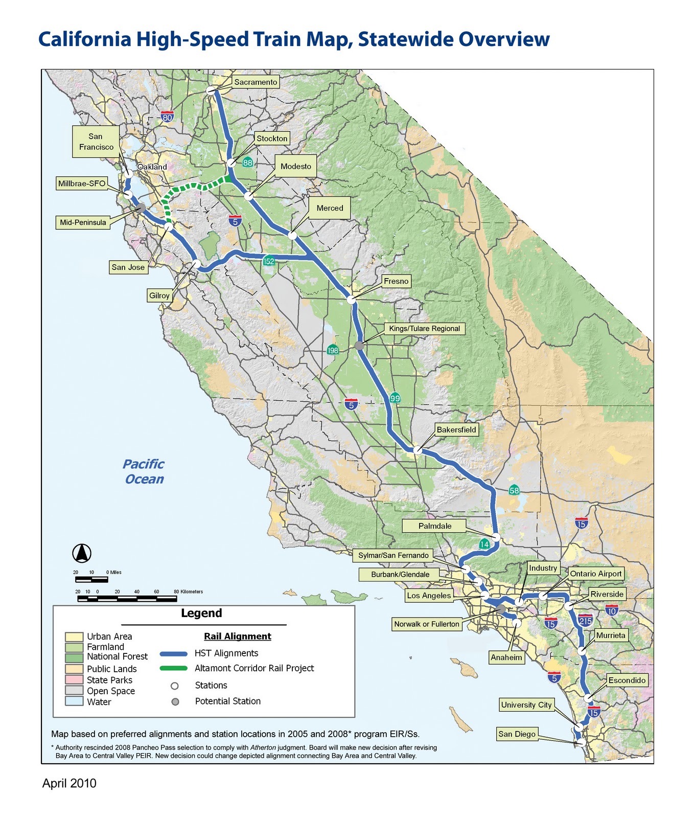
A fully funded network will have 26 stations, serving cities that contain the vast majority of the state's residents

After a general overview of HSR, and some caveats--these recs are "bird's eye view," they won't get into specifics of station design, alignments, etc--Regional Planning Director, and chief powerpoint clicker Egon Terplan got down to business. The recommendations turned out to be fairly unsurprising, at least for anyone familiar with the work that SPUR does, yet certainly good, worthy, and salient. The presentation left me hankering for a longer format presentation, one that would delve into the site-specific details of individual station areas. That's where the real creative/pragmatic alchemy would be, not in a list of general principles--I mean, find me a planner who would disagree with making the area around the station a "destination." Nonetheless, general principles are critical for establishing goals and expectations, so it's worthwhile to lay them out. Rather than reproduce each of the 13 recs, I'm condensing them, because let's face it, I've never been the linear note-taking type.
  • Station Area Plans for each of the 26 HSR station areas. Density minimums, parking maximums, integrated access to intermodal feeder networks.
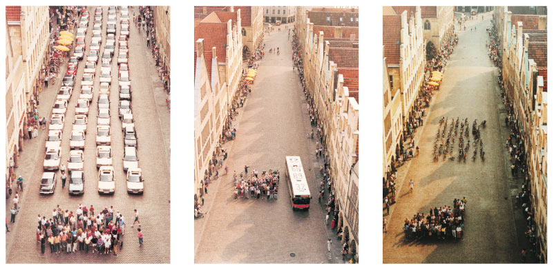
Station Area Plans are the necessary starting point for generating maximal utility from each station. As SPUR noted, it is perfectly conceivable for HSR to follow the footsteps of BART, or airports, and become functioning transportation hubs surrounded by surface level parking and other low-rise, low-density uses. This would be counterproductive in several ways.

One, it forfeits HSR's unique ability to create incentives for denser developments, essentially giving up the potential for concentrated investment in what will typically be the city's downtown area. Two, denser uses around the station ensure higher station use: more office space, more commercial space, convention centers, high(er) rise residential will make HSR more relevant. Third, using the space around the station intensely, but also with an eye toward public spaces and the unique dimensions of each city will create good urban places. Good urban places will increase the feedback loop of investment and HSR ridership. Fourth, development at each station will help prevent the system from making CA into one big commutershed. Surrounding a station with parking and low-rise residential will only encourage riders to use HSR as a commuter train on steroids, and extend the bedroom communities of SF, SJ, and LA into the central valley. Some movement in that direction will undoubtedly occur, but far better to work toward making those places destinations and job sources in and of themselves.

Not this: North Berkeley BART

Not this either: Oakland Airport. The "A" placemarker is in the middle of a parking lot

Terplan also noted that in France, many cities lacked light rail before TGV stops were built. Presence of TGV spurred investment in local links and feeder routes, dramatically increasing the connectivity of the area as a whole, above and beyond simply getting to and from the station. An HSR station would certainly require re-jiggering local transit routed, and I'm hopeful that this could lead to some new investments and transit ridership.

A problem is that the state of CA lacks either the political will or the legal authority (different opinions were offered on this point) to mandate station plans, which leads to:
  • Financial incentives for local governments to make Station Area Plans: Matching grants, Revolving loans.
Funds are always hard to come by, but plans have the advantage of being relatively cheap. Terplan singled out general obligation bonds like Prop 84 from a few years back as initiatives that could tuck away the $1 million or so necessary for a good plan. Takeaway here is that sans incentives means cities sans resources for far-reaching plans.
  • Incentives for the type of Station Area Plan SPUR favors: TIF for TOD
Little as the state can dictate what a municipality must plan, it has less control over how it should plan. (An interesting comparison here, to Japan, where the company unrolling the HSR there also had a real-estate development arm that got to plan areas around the station just how it wanted. Nice.) Tax Increment Financing (TIF; TOD stands for Transit Oriented Development) is a tool I've already documented, and certainly a way for cities to capture the value of HSR. Read: shake the money tree. Only problem is, in order to establish a TIF zone, you need to show evidence of blight. Terplan mentioned that a few years ago there was a drive to introduce legislation that would classify HSR stations as sufficient grounds to create a TIF zone. Were this to be revived and passed, public and private bodies would have lucrative incentives to make areas around HSR into high yield places. Another obstacle: many areas around stations are already part of an existing TIF zone, and thus their tax revenue is already spoken for. And all this assumes that the best way to use this land is with the uses that will generate the highest property tax revenue ... this would have substantial transformative power, but little power to preserve the existing character of a city. While investment and prosperity are great, it would be a shame to see the homogenization this could unleash if improperly handled. To say nothing of gentrification.

Another potential strategy the presentation mentioned was land banking. This sounds like free market eminent domain, as Terplan described the process as buying up land around the future station site in order to have more direct control over the kind of development that takes place on it. Such a move would likely be a wise investment by whatever party doing the buying, though in the ideal, local towns and cities would have the say.
  • Implementation Program
How would a city move from Station Area Plan to reality? Provisions would be needed for updating local General Plans in accordance with Station Area Plans--zoning laws being perhaps the most relevant. Some streamlining of permit acquisition and Environmental Impact Report requirements was also discussed, provided that a project fit within the recommendations of the Station Area Plan. Additionally, a financing plan and assessment district structure could generate revenue to operate the HSR station.
  • Oversight and preservation
I don't have as much detail on these, but accountability matters, so I thought I'd give it a shout out. My notes shout out the HSR Authority, Caltrains, HCD amd OPR as hypothetical oversight agents, though what they would be empowered to do is entirely unclear. Preservation was mostly framed as preserving agricultural land against potential sprawl. Urban growth boundaries and agricultural easements could mitigate this, though the process of putting those in place would likely fall completely to local governments.

Given that local municipalities exercise control over local planning issues, and the absence of a robust incentive system, HSR seems fated for divergent station outcomes. Some will likely generate sprawl, surface parking, commuting, and bedroom communities, while others will change city centers into places more along the lines of SPUR's vision. Assuming the whole project even gets built, which is still a big assumption.

November 7, 2010

Public/Private Partnerships for Transit

Interesting news coming out of Chicago, courtesy of the Streetsblog network. A few months ago, I noted that the Mayor Daley-privatized parking meters represented a potential of $9 billion dollars in lost revenue.

Now, the revenue is flowing into, not out of the city: Apple has plunked down $4 million to renovate the subway stop near it newest Chicago store. Blair Kamin covers it in his Cityscapes column. Powerwashing, new street level facades, new plaza + fountain and seating.

Before

After

Sure, there's Apple-only (for now, at least?) advertising inside the station, and there's the postmodern specter of corporations owning ever greater parcels of public space and therefore eventually usurping your very consciousness, but ... this doesn't seem like a bad idea to me.

An article in the Chicago Tribune noted the station's context:
Even while the neighborhood took on a high gloss, the CTA station looked the way it had for decades — like the stop closest to the poverty of the Cabrini-Green housing project.
This could be an instance of a private entity moving in to upgrade a low-priority project ... granted, funds are tight for the CTA and transit agencies everywhere, but I wonder whether the projects deterred CTA investment in the station.

There's also talk of selling the station's official naming rights to Apple.

Hmm, maybe Zachary's Pizza could spruce up the Rockridge station ... I'm thinking a ski gondola, or Ooh! a zipline to the storefront would be sweet. And the Zachary's poster contests could be expanded to redecorate the station. Done.