 |
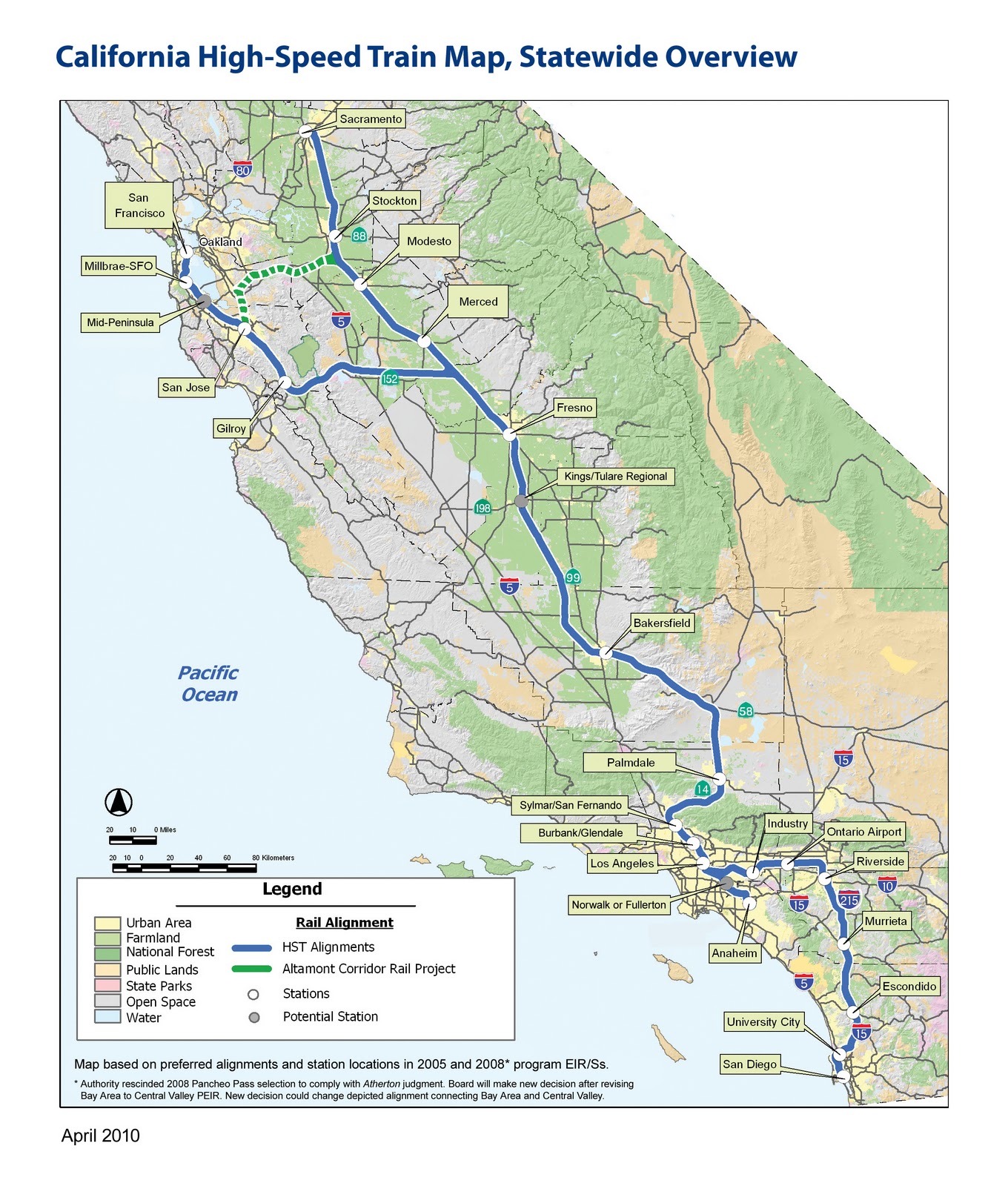
| A fully funded network will have 26 stations, serving cities that contain the vast majority of the state's residents |
After a general overview of HSR, and some caveats--these recs are "bird's eye view," they won't get into specifics of station design, alignments, etc--Regional Planning Director, and chief powerpoint clicker Egon Terplan got down to business. The recommendations turned out to be fairly unsurprising, at least for anyone familiar with the work that SPUR does, yet certainly good, worthy, and salient. The presentation left me hankering for a longer format presentation, one that would delve into the site-specific details of individual station areas. That's where the real creative/pragmatic alchemy would be, not in a list of general principles--I mean, find me a planner who would disagree with making the area around the station a "destination." Nonetheless, general principles are critical for establishing goals and expectations, so it's worthwhile to lay them out. Rather than reproduce each of the 13 recs, I'm condensing them, because let's face it, I've never been the linear note-taking type.
- Station Area Plans for each of the 26 HSR station areas. Density minimums, parking maximums, integrated access to intermodal feeder networks.
One, it forfeits HSR's unique ability to create incentives for denser developments, essentially giving up the potential for concentrated investment in what will typically be the city's downtown area. Two, denser uses around the station ensure higher station use: more office space, more commercial space, convention centers, high(er) rise residential will make HSR more relevant. Third, using the space around the station intensely, but also with an eye toward public spaces and the unique dimensions of each city will create good urban places. Good urban places will increase the feedback loop of investment and HSR ridership. Fourth, development at each station will help prevent the system from making CA into one big commutershed. Surrounding a station with parking and low-rise residential will only encourage riders to use HSR as a commuter train on steroids, and extend the bedroom communities of SF, SJ, and LA into the central valley. Some movement in that direction will undoubtedly occur, but far better to work toward making those places destinations and job sources in and of themselves.
 |
| Not this: North Berkeley BART |
 |
| Not this either: Oakland Airport. The "A" placemarker is in the middle of a parking lot |
Terplan also noted that in France, many cities lacked light rail before TGV stops were built. Presence of TGV spurred investment in local links and feeder routes, dramatically increasing the connectivity of the area as a whole, above and beyond simply getting to and from the station. An HSR station would certainly require re-jiggering local transit routed, and I'm hopeful that this could lead to some new investments and transit ridership.
A problem is that the state of CA lacks either the political will or the legal authority (different opinions were offered on this point) to mandate station plans, which leads to:
- Financial incentives for local governments to make Station Area Plans: Matching grants, Revolving loans.
- Incentives for the type of Station Area Plan SPUR favors: TIF for TOD
Another potential strategy the presentation mentioned was land banking. This sounds like free market eminent domain, as Terplan described the process as buying up land around the future station site in order to have more direct control over the kind of development that takes place on it. Such a move would likely be a wise investment by whatever party doing the buying, though in the ideal, local towns and cities would have the say.
- Implementation Program
- Oversight and preservation
Given that local municipalities exercise control over local planning issues, and the absence of a robust incentive system, HSR seems fated for divergent station outcomes. Some will likely generate sprawl, surface parking, commuting, and bedroom communities, while others will change city centers into places more along the lines of SPUR's vision. Assuming the whole project even gets built, which is still a big assumption.
No comments:
Post a Comment