Showing posts with label Land use. Show all posts

March 24, 2011

New SF Affordable Housing

SJ Mercury News: The Metropolitan Transportation Committee has committed $10 million to a $50 million revolving fund for affordable housing near transit stops. Morgan Stanley, Citi Community Capital, and several other financial and nonprofit groups to create the fund, called the Bay Area Transit Oriented Affordable Housing Fund.
Officials plan to make the first $4.8 million loan to buy a San Francisco parking lot where developers plan to construct a 14-story building with 150 apartments and a ground-floor grocery story at Eddy and Taylor streets.
It's great to see money being freed up for housing, post economic liquidity/loan contraction. Affordable housing is also chronically underfunded, as, you know, incentives skew more strongly toward non-affordable housing (read: luxury condos). Such is life, such is the market.


Map:


Street view:

Of course, the shortage of parking in SF is a bone of contention. But in the heart of downtown, I can think of better lot uses than car storage.

November 23, 2010

Redevelopment vs. Preservation in SF

Writing SoMa history | San Francisco Examiner

Interesting snapshot of the investment that may/will unfold with the arrival of HSR and the Transbay Terminal. Proponents of HSR argue that areas adjacent to planned stations will receive this attention up and down the state-long route, and with it come concerns about preserving the character of the existing space. Preservation is a tricky beast to tame, and a glance at the comments will tell you why:

Planning tends to do a really mixed-up choc-a-bloc pastiche when they get into this micr0 management mode. It the Mission they arbitrarily took whole blocks that had been mixed use, and locked them down under "industrial preservation." Now many of those buildings sit empty because the "industry" has long since moved out and there is no flexibility to re-purpose the buildings.

Meanwhile individual neighbors are jammed up against industrial space that is neglected.

And:
Sixth Street Lodging District?!?!? Are you f-ing kidding me? Let's make sure we preserve the homeless and criminals that do with it and that live in these "historical" buildings. Better yet, in order to preserve the true character of the neighborhood, let's dress all the homeless like 1930 bums and call is Skid Row again. We can sell tickets!
Preservation can be a powerful tool to prevent slash and burn redevelopment that makes every place look like noplace, and whether these commenters are right or wrong, it can also hamstring economic growth, and result in arbitrarily preserved eyesores. It is also selectively wielded, and though Examiner reporter Kamala Kelkar doesn't come right out and say it, bias is implied. SoMa and the Mission have been targeted for preservation against overzealous developers, while (the last historically black neighborhood left) Hunters Point was not. Nor, in decades past, was the Fillmore area, known as "The Harlem of the West."

I've given my snapshot of California Redevelopment Laws in an earlier post, and it is safe to say that the system favors the monied and powerful in their quest to remain monied and powerful. It accomplishes this by creating powerful incentives to replace underperforming/poor areas with uses that generate more impressive revenues: luxury condos and big box regional retail being perhaps the foremost. Preservation needs a place at the table, as I think it's usually best to regard redevelopment skeptically until proven otherwise.

October 4, 2010

More on Density

From Human Transit, where I am increasingly impressed by the frequency and quality of the posts.

Can we make density make sense? is the latest post about, well, how to handle density data.

Main conclusion is that density per population--What percentage of the population lives at densities above x? What's the average density at which people in this city live?--may be more useful than density per area--people per square mile, or whathaveyou.

Both this new post and its predecessor have excellent comment threads, for those with greater than average curiosity.

Urban Planning and Safety

First, Straight Outta the Suburbs. In my digi-travels, I've read many an urban planning blog, but ones focusing on the less-sexy hinterlands are harder to come by. Quality stuff.

SOtS posted an interesting nugget from the LAPD's Crime Prevention Through Environmental Design pamphlet: the increased "natural surveillance" and eyes-on-the-street that mixed-use developments generate are in the interest of public safety. SOtS post here, LAPD pamphlet here. (pdf)

I've written here and here about why the need for better suburbs is not merely a matter of taste, and this pamphlet add another dimension: safety. Even though the LAPD pdf could use a little graphic design assistance, it's got some pointed pointers:

  • Provide clear border definition of controlled space (e.g., fences, hedges, paving patterns and low walls). Avoid unassigned space. As much as possible, all space should become the clear responsibility of someone.
By way of example, most mid-century housing projects fail this test, though on a scale vastly more humongous than anything the LAPD pamphlet had in mind. Their aesthetically-driven embrace of unassigned space was a significant part of their failure, and though such projects are unlikely to be repeated (at least on that scale), it's worth reminding ourselves of the essential lessons they provide about the dialog between safety, design, and urban connectivity.
  • Place activities in locations to overcome vulnerability of these activities with natural surveillance and access control of the safe area. For instance, common toilet facilities and laundry rooms should not be located in a remote corner of the site or at the end of a long nameless hallway. Locate these facilities (unsafe) adjacent to the entry or location where there is normally high foot traffic (safe).
This is perhaps more of an architectural detail, one I hadn't considered. Pomona alums, I'm thinking of the Oldenborg laundry rooms right now. Those gave me the creepers in a way that Mudd-Blaisdel's never did.

Though these warnings are useful for planners of suburban spaces (all spaces, really), I think their most urgent applications are found where someone tried to insert suburban/garden city style planning (lots of ambiguous space) into high density, high poverty urban settings. Worst mix.

October 1, 2010

North Camino Ramon Plan: The Vision vs. The Present

The North Camino Ramon Plan has captivated me at least in part because its projected vision is vastly different from its current reality. As the plan states, it:
strives to meet sustainability and greenhouse gas reduction goals as the plan area transforms from an automobile-dominated, low-density commercial area to a transit- and pedestrian- oriented neighborhood that will be a community focal point with a mix of uses.
For all of you who have never been to San Ramon before, I decided to do some quick and dirty photojournalism to give you a sense of exactly how "automobile-dominated, low density" the plan area is. Slideshow @ the end.

One thing I noticed was that if you cleared the parking lots of landscaped curbs, cleared fences between parking lots, and cleared elevation grades, you would have a lot of room to build. As I biked around, I was frequently able to thread different parking lots into an ersatz right-of-way. Removing barriers between the lots would not a street network make, but there would be room for one. I say this without taking any measurements, or thinking about space for the buildings the City would presumably want to build along the new streets.

The blue arrows in the map below mark "parking lot rights of way" that, given either a dose of eminent domain, reform-minded ownership, or vigilante jackhammers, could become streets without bulldozing buildings. The red arrows mark routes that would need ... something more drastic. The blue circle corresponds to the planned center of the park that would itself lie at the middle of the mixed use retail/office/residential neighborhood.

This bears a passing similarity to the official plan:


I wonder if the final plan will insist on perfectly straight streets--a few kinks could avoid a big Planners vs. Community stand-off. But let's be clear, the parking lot right of way, even with street kinks, makes the eventual plan only a smidgen less ambitious. Those businesses all want their parking, and will be loathe to relinquish it. And the parking lot that's planned to replace lost surface parking (#5), looks like it will be built over office buildings that include local insurance agencies, HVAC management software, kiddie hair salons, and local soccer league administration. The other building the lot would replace houses the City of San Ramon offices, but hey, they've got greener grass in mind anyway: plans to build a new city hall complex (pdf) just south of this North Camino Ramon Development.

In any case, check out the slideshow of pictures I took. Here's a rough map of the route, to help you locate yourselves. The first picture starts on the northernmost street, looking west (AKA left, looking at the map), then south, then east, then the route kicks in.


"Automobile-dominated" indeed:


September 27, 2010

Why Suburban Retrofits Matter, Part II

Earlier I posted a quick list of reasons why suburban retrofits are more than just a matter of taste, and today I turn my attention to the outward migration of jobs and office space, from city to suburbs.

A local example of this shift made headlines earlier this week: Clorox, the Oakland-headquartered cleaning product empire, is moving as many as 700 jobs to a new campus in suburban Pleasanton. Clorox plans to enlarge the campus, formerly occupied by Washington Mutual, by 65,000 square feet, and sell its existing Pleasanton campus. It will also be looking for new tenants to occupy the bottom 12 floors of its Oakland skyscraper, though the company has stated intentions to remain headquartered there. After the shift, both locations are expected to house around 900 employees.

Clorox's suburban migration is not an isolated case. In a 2000 report by the Center on Urban and Metropolitan Policy at the Brookings Institute, author Kenneth Lang found significant growth disparities. A picture is worth a thousand words:


Lang goes on to distinguish between suburbs categorized as Edge Cities and those that are more appropriately termed Edgeless Cities.

Edge Cities--like Walnut Creek, CA, or Tysons Corner, VA--are well defined places, always with favorable highway access, usually in proximity to transit to urban cores, that have a successful mix of suburban single family homes ringing a well-to-do business district. In short, they are centralized places at the edge of metropolitan areas. They have boundaries.

Edgeless cities, as the name implies, are more entropic. They are rather like San Ramon: made up of free-standing buildings, office parks, or small clusters of buildings of varying densities. They usually lack a center, and are not considered destinations, though they may meet utilitarian errand-running needs.

With this distinction in mind, here are more data:


As Lang writes, "People increasingly commute from dispersed locations to dispersed locations." I do not doubt this, but it would be interesting to learn more about what metrics tip a city from Edge to Edgeless. In Lang's report, Edgeless Cities are "highly dispersed clusters featuring less than 5 million square feet of space." So cluster of office space greater than 5 million square feet is an Edge City--this seems like an oversimplification.

The implications of these shifting trends are hard to enumerate in a satisfying way. What's clear is that while central cities are still growing, most growth is spreading outward. But instead of far-flung housing developments that retain established centers as their point of reference, the new office developments fold the system outward in unexpected ways.

My takeaway is that suburbs are increasingly trapped between the use their design would predict--bedroom communities for an urban core--and what they are increasingly used for--a source of employment and whatever kind of civic life can be found. The outward spread of office space, especially in such a dispersed manner, makes transportation planning more difficult and traffic patterns more multi-nodal. With increased auto dependency comes greater segregation of uses, fewer public gathering places, and fewer occasions for pride in or ownership of one's built environment. If there's nothing there worth identifying with ... then what?

I think the rootlessness of these places is what gets to me the most, but what's a planner to do? Dispersed office growth just makes planning well-used and well-liked areas that much more challenging. The former destroys density, the latter needs it. My worry is that it seems condescending for a planner to say, "sure your development is functional, but here's are some changes you should make to improve your quality of life." It seems more reliable to stick to "improve your tax base/traffic patterns/air quality."

Which is my way of saying that I wish Lang's report had quantitative data about the effect of suburban office growth on tax bases/traffic patterns/air quality, rather than leaving me to surmise about the qualitative unsavoriness of living in one of the ascendant Edgeless Cities.

September 24, 2010

San Ramon Plans for New Urbanist Infill Project

The City of San Ramon has an ambitious plan. I'll frame it, hit some key design points, show a few maps, a few stumbling blocks, and some parting thoughts. All information is from the September 23rd Staff Report on this page.

The Frame

Today the city of San Ramon hosted a public comment session on its North Camino Ramon Specific Plan (NCRSP). The planners are speaking a language I did not expect to hear in this rather conservative, automobile-embracing slice of of suburbia. From the online staff report:

The North Camino Ramon Specific Plan seeks to facilitate the redevelopment of the Specific Plan area and strives to meet sustainability and greenhouse gas reduction goals as the plan area transforms from an automobile-dominated, low-density commercial area to a transit- and pedestrian- oriented neighborhood that will be a community focal point with a mix of uses.
As a nearby resident and frequent patron of existing stores who assumed that the garbled vomit of retail surface parking megablocks surrounded by clogged arterials would never change, I'm ... stunned.

Key Design Points

  • The adoption of General Plan 2030 would re-designate all properties within the Specific Plan area not currently designated “Mixed Use” to “Mixed Use.”
  • The preliminary draft calls for displacing 2,650,000 sq ft of retail, and adding in 4,325,000 new sq ft. 1500 dwelling units (1,650,000 sq ft) are also planned.
  • A street loop will create new frontage for multi-level mixed use retail, restaurant, office, and residential uses, and enclose a linear public park: "a well-designed gathering place with site amenities and quality landscape features."
  • The Transit Center, currently hidden in a commuter's only spot in the heart of Bishop Ranch, will relocate to the southern end of the street loop.
  • Shared parking. Sounds boring, but this is a lynch-pin. Developments like these that have separate parking reqs for each tenant end up with a sea of duplicated parking. When each store has its own lot, drivers are encouraged to drive from place to place, rather than park once. Under such conditions, parking once would also be plain inconvenient; parking lots on foot are boring, unsafe, and take a long time to traverse.
  • A broad landscaped path will link the Iron Horse Trail to the Commons, Transit Center, and will be designed to assist capture and filtration of runoff. The development at Camino Ramon and Sycamore in Danville completely failed at connectivity with the IHTrail, and it abuts the darn thing. Big plus here for ped and cycling connectivity.
  • Secondary Streets. A Jane Jacobs-approved attempt at street gridding and connectivity that gives circulation options to people on foot. And increases street frontage lots for sale.
  • Bishop Ranch Consolidation. "Relocation of the existing Bishop Ranch office space from other parcels within the Specific Plan area will be encouraged to allow more intensive development of other commercial and residential use." How they plan to entice/move existing office buildings around is beyond me.
  • Diversified housing options. "Loft units, apartments over retail stores, apartment and condominium buildings, townhouses, rowhouses, and live/work units" for young professionals who like to be near commercial areas and possible employers.

A Few Maps

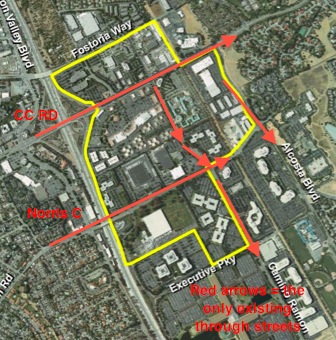
A bird's eye view of the North Camino Ramon Specific Plan.


The write-overs I did underwhelm in the legibility dept, so from the top down: CC Road, Norris C (Road), and "Red arrows = the only existing through streets."

As you can see, super blocks engulfing parking engulfing retail/offices. It's possible to traverse most of this area in your car without ever leaving a parking lot.

Got that spatially mapped? Here's the tentative plan, screen-captured from the Staff Report pdf.

I really wish they had done this with transparent color coding--seeing the existing built environment would be much more useful. After some tedious split screen comparing (and heck, I know this area really well), I was able to see a few stumbling blocks.

A Few Stumbling Blocks

1. The street loop/mixed use core/linear public park bisects an existing supermarket. Now as much as I'd like to see a complete street routed down the snack food aisle of my local Lucky's, this seems improbable. And if not Lucky's per se, the street might cut through Big 5 Sporting Goods, or Ruggies, or Thrifty. I don't think they'd be keen either. I'm curious whether the City can tell either a) the store, b) the developer who owns the property or c) both, "clear out, we're putting a retail, sidewalk, parking, street, sidewalk, public park, sidewalk, street, parking, sidewalk, retail sandwich right through the property you have prosperously occupied for, I don't know, at least as long as the author of this blog post has been breathing. Eminent domain? Does the City actually own that land? Can they force them out? Mmm ... property law and contract law would be useful here ...

There's also a big hunk of 24 Hour Fitness where the #10 #3 #7 triangle is on the above map. I'm sure there are more examples, but for the sake of length I'll move on. Let the record show that I cannot wait to see how they will re-build the built environment.

2. The secondary streets won't create blocks as small as downtown Danville's, which will be the reference point for just about all future users of this future "downtown" space. Smaller blocks = more walkable and browsable, but I suspect stumbling block #1 above is the reason why more streets are not going in.

3. By far my biggest stumbling block is looking at the existing land use, and reading their plan, and saying "impossible." If you've used this area, you know that this plan is the diametric opposite of everything you associate with the space.

Parting Thoughts: Visualizing the Transformation, Difficultly

I'll be back with some ground level pictures tomorrow, but I'll leave you with a closer look at the sense of impossibility I feel.

A closer look at the northwest corner. The "w," "m," and "ng" in "Crow Canyon Commons Shopping Center" mark the new street + park + retail loop route. And you can see there is very much a building in the way, and more beyond it.

All three of the secondary cross streets will be on this parcel. Hard to imagine with so many buildings in the way! I think one of the secondary streets (the one just north of "#1" on the above plan) will intersect the new street + park + retail loop by running along the line of green that demarcates the parking lot border between the clusters of office buildings south of the CC Commons Shopping Center, and north of the 24 Hour Fitness (the dark gray rectangle partially cut off by the lower frame). The other two will go north and south of that one, though how they will finagle the right of way is beyond me.

And please, please note the oceans of underperforming asphalt parking. Can't wait to see them repurposed.

September 17, 2010

What We're Reading: Retrofitting Suburbia

Retrofitting Suburbia: Urban Design Solutions for Redesigning Suburbs is the full title, and totally encapsulates the tome's intent.

What's been most interesting so far are the market forces it describes. To authors Ellen Dunham-Jones and June Williamson, the financial incentives for retrofitting are present and only gathering more steam.

To wit:
  • Reduced percentages of suburban households with children
  • Growing market for multiunit housing in suburban locations
  • Continued growth in percentage of jobs in suburban locations.
  • First-ring suburbs that are aging and depopulating, and becoming comparatively central thanks to newer, farther-flung developments
And here's a quote that stood out for multiple, perhaps paradigm shift-related reasons:

"The future promises to alter our relationship to place as we continue to shift from an industrial to a postindustrial economy and society. This economy is digitally enabled to be less dependent on geography, making the qualities of individual places matter more in locational decisions ... a primary goal is to build and support an identifiable, durable place to which people will be attracted."

At first I thought, you ninny, we are obviously post-industrial. Then I remembered that I am 24, and the author could be double my age. I've never even really lived in an industrial economy, so acknowledging post-industrialism feels calling my music habits post-vinyl.


My second impression is that her assessment of our evolving geography is on point. A knowledge economy is, at least comparatively, a movable feast. In determining where to look for jobs, or where I'd like to live, I determine my shortlist exclusively by quality of place. After that cut, other factors dominate (well, just one, really--employment), but I hadn't really considered the implications of such radical mobility. With the power of the internet fueling national and international job searches and instant information gathering, the barriers to getting a job in x place because it seems like the bomb.com get lower and lower. And let's get tighter: even moving to x neighborhood, or x street. It seems more people than ever have* the kind of choosing power and information re location and place that is traditionally reserved for appliances and car stereos. A more powerful customer can certainly shift the old demand curve ...

*Or do they? Having a family with a stable financial background and a college education seem completely essential here. And those are two big caveats. As suburban places improve and diversify their land-use in desirable ways, I wouldn't be surprised if traditionally marginalized groups get priced/elbowed out into the newly least desirable spaces ... actually I kind of expect it. Keeping the less-mobile in mind will be critical to ensuring that the boon from these market forces (better places) are equitably available.

September 13, 2010

Jacobs Distillation

Having finished Death and Life of Great American Cities, I have now, just now, located a convenient summation. Some chap has typed up a bunch of JJ notable quotables. Thanks, hivemind!

Here's the real clincher:

The generators of diversity
"To generate exuberant diversity in a city's streets and districts, four conditions are indispensable:
1. The district, and indeed as many of its internal parts as possible, must serve more than one primary function; preferably more than two. These must insure the presence of people who go outdoors on different schedules and are in the place for different purposes, but who are able to use many facilities in common. 
2. Most blocks must be short; that is, streets and opportunities to turn corners must be frequent.
3. The district must mingle buildings that vary in age and condition; including a good proportion of old ones so that they vary in the economic yield they must produce. This mingling must be fairly close-grained.
4. There must be sufficiently dense concentration of people, for whatever purposes they may be there. This includes dense concentrations ... of people who are there because of residence.
The necessity for these four conditions is the most important point this book has to make. In combination, these conditions create effective economic pools of use" (151).

Downtown Danville has points 1, 2, and 3, and notably, is a major asset to the town region--a justifiable magnet for folks in the suburbs radiating around it who get bored by all the dullness. Apart from Walnut Creek, it is probably the only town center on the 680 corridor built for pedestrians. Maybe parts of Pleasanton and Livermore would take offense at that. Though I cannot speak for its brethren, I know Dt Danville was laid out before the car. Hence, the short blocks and sidewalk building frontages.

Pretty much everything else around it is chain retail behind acres of parking. Progress!