Showing posts with label Density. Show all posts

November 11, 2010

SPUR Lunch Talk: CA High Speed Rail and Land Use

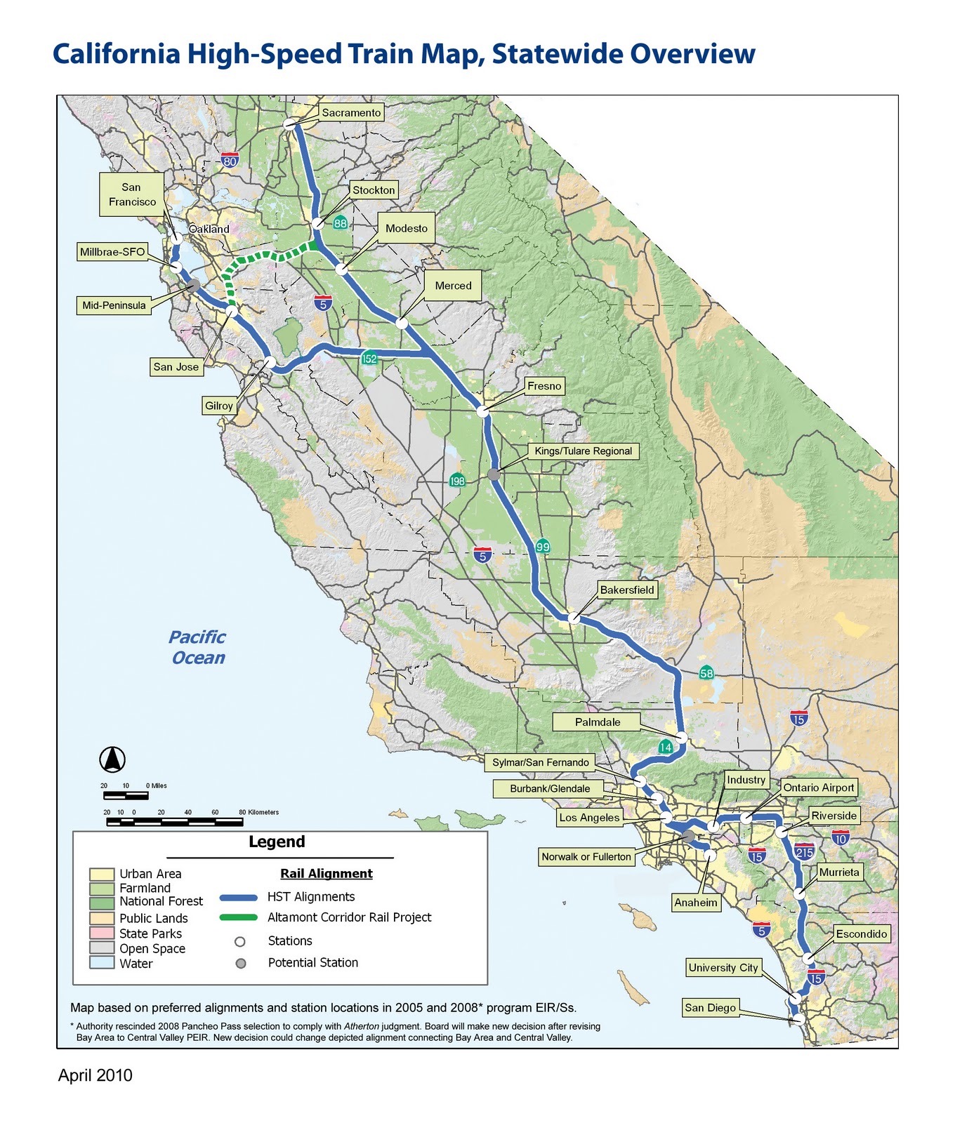
The San Francisco Planning and Urban Research group (SPUR) hosted a lunch forum today in which it presented 13 recommendations for land use plans around future/hypothetical CA high speed rail stations.

A fully funded network will have 26 stations, serving cities that contain the vast majority of the state's residents

After a general overview of HSR, and some caveats--these recs are "bird's eye view," they won't get into specifics of station design, alignments, etc--Regional Planning Director, and chief powerpoint clicker Egon Terplan got down to business. The recommendations turned out to be fairly unsurprising, at least for anyone familiar with the work that SPUR does, yet certainly good, worthy, and salient. The presentation left me hankering for a longer format presentation, one that would delve into the site-specific details of individual station areas. That's where the real creative/pragmatic alchemy would be, not in a list of general principles--I mean, find me a planner who would disagree with making the area around the station a "destination." Nonetheless, general principles are critical for establishing goals and expectations, so it's worthwhile to lay them out. Rather than reproduce each of the 13 recs, I'm condensing them, because let's face it, I've never been the linear note-taking type.
  • Station Area Plans for each of the 26 HSR station areas. Density minimums, parking maximums, integrated access to intermodal feeder networks.
Station Area Plans are the necessary starting point for generating maximal utility from each station. As SPUR noted, it is perfectly conceivable for HSR to follow the footsteps of BART, or airports, and become functioning transportation hubs surrounded by surface level parking and other low-rise, low-density uses. This would be counterproductive in several ways.

One, it forfeits HSR's unique ability to create incentives for denser developments, essentially giving up the potential for concentrated investment in what will typically be the city's downtown area. Two, denser uses around the station ensure higher station use: more office space, more commercial space, convention centers, high(er) rise residential will make HSR more relevant. Third, using the space around the station intensely, but also with an eye toward public spaces and the unique dimensions of each city will create good urban places. Good urban places will increase the feedback loop of investment and HSR ridership. Fourth, development at each station will help prevent the system from making CA into one big commutershed. Surrounding a station with parking and low-rise residential will only encourage riders to use HSR as a commuter train on steroids, and extend the bedroom communities of SF, SJ, and LA into the central valley. Some movement in that direction will undoubtedly occur, but far better to work toward making those places destinations and job sources in and of themselves.

Not this: North Berkeley BART

Not this either: Oakland Airport. The "A" placemarker is in the middle of a parking lot

Terplan also noted that in France, many cities lacked light rail before TGV stops were built. Presence of TGV spurred investment in local links and feeder routes, dramatically increasing the connectivity of the area as a whole, above and beyond simply getting to and from the station. An HSR station would certainly require re-jiggering local transit routed, and I'm hopeful that this could lead to some new investments and transit ridership.

A problem is that the state of CA lacks either the political will or the legal authority (different opinions were offered on this point) to mandate station plans, which leads to:
  • Financial incentives for local governments to make Station Area Plans: Matching grants, Revolving loans.
Funds are always hard to come by, but plans have the advantage of being relatively cheap. Terplan singled out general obligation bonds like Prop 84 from a few years back as initiatives that could tuck away the $1 million or so necessary for a good plan. Takeaway here is that sans incentives means cities sans resources for far-reaching plans.
  • Incentives for the type of Station Area Plan SPUR favors: TIF for TOD
Little as the state can dictate what a municipality must plan, it has less control over how it should plan. (An interesting comparison here, to Japan, where the company unrolling the HSR there also had a real-estate development arm that got to plan areas around the station just how it wanted. Nice.) Tax Increment Financing (TIF; TOD stands for Transit Oriented Development) is a tool I've already documented, and certainly a way for cities to capture the value of HSR. Read: shake the money tree. Only problem is, in order to establish a TIF zone, you need to show evidence of blight. Terplan mentioned that a few years ago there was a drive to introduce legislation that would classify HSR stations as sufficient grounds to create a TIF zone. Were this to be revived and passed, public and private bodies would have lucrative incentives to make areas around HSR into high yield places. Another obstacle: many areas around stations are already part of an existing TIF zone, and thus their tax revenue is already spoken for. And all this assumes that the best way to use this land is with the uses that will generate the highest property tax revenue ... this would have substantial transformative power, but little power to preserve the existing character of a city. While investment and prosperity are great, it would be a shame to see the homogenization this could unleash if improperly handled. To say nothing of gentrification.

Another potential strategy the presentation mentioned was land banking. This sounds like free market eminent domain, as Terplan described the process as buying up land around the future station site in order to have more direct control over the kind of development that takes place on it. Such a move would likely be a wise investment by whatever party doing the buying, though in the ideal, local towns and cities would have the say.
  • Implementation Program
How would a city move from Station Area Plan to reality? Provisions would be needed for updating local General Plans in accordance with Station Area Plans--zoning laws being perhaps the most relevant. Some streamlining of permit acquisition and Environmental Impact Report requirements was also discussed, provided that a project fit within the recommendations of the Station Area Plan. Additionally, a financing plan and assessment district structure could generate revenue to operate the HSR station.
  • Oversight and preservation
I don't have as much detail on these, but accountability matters, so I thought I'd give it a shout out. My notes shout out the HSR Authority, Caltrains, HCD amd OPR as hypothetical oversight agents, though what they would be empowered to do is entirely unclear. Preservation was mostly framed as preserving agricultural land against potential sprawl. Urban growth boundaries and agricultural easements could mitigate this, though the process of putting those in place would likely fall completely to local governments.

Given that local municipalities exercise control over local planning issues, and the absence of a robust incentive system, HSR seems fated for divergent station outcomes. Some will likely generate sprawl, surface parking, commuting, and bedroom communities, while others will change city centers into places more along the lines of SPUR's vision. Assuming the whole project even gets built, which is still a big assumption.

October 29, 2010

A Unified Theory of Urban Living

An article in a recent issue of Nature (hat tip to KH) makes the case for quantifying, or at least systematizing, our understandings of how cities and urban spaces operate. Citing past mistakes in urban planning, the authors argue that "the need is urgent for an integrated, quantitative, predictive, science-based understanding of the dynamics, growth and organization of cities. To combat the multiple threats facing humanity, a ‘grand unified theory of sustainability’ with cities and urbanization at its core must be developed."

An ambitious undertaking to say the least, but they point out a few interesting findings as evidence that such an effort might be possible. To wit:

Three main characteristics vary systematically with population. One, the space required per capita shrinks, thanks to denser settlement and a more intense use of infrastructure. Two, the pace of all socioeconomic activity accelerates, leading to higher productivity. And three, economic and social activities diversify and become more interdependent, resulting in new forms of economic specialization and cultural expression.
We have recently shown that these general trends can be expressed as simple mathematical ‘laws’. For example, doubling the population of any city requires only about an 85% increase in infrastructure, whether that be total road surface, length of electrical cables, water pipes or number of petrol stations. This systematic 15% savings happens because, in general, creating and operating the same infrastructure at higher densities is more efficient, more economically viable, and often leads to higher-quality services and solutions that are impossible in smaller places.

So far, pretty common sense. A friend once remarked to me that New York's density subsidizes US Postal Service deliveries to rural towns with populations in the 100s--dropping mail to addresses with dozens of residents is certainly more cost efficient than dropping mail to single resident addresses several miles apart.

What gave me pause was the mathematical regularity the researchers found:

Now, the friend who alerted me to this article assures me that a statistical relationships this iron clad are a rare sight in the world of real world data. Because I know little about groovy tactics like taking the log of each axis, I'll let his judgment and the commanding visual speak for itself (the line looks like a backslash, for goodness sake).

The bigger the city, the more the average citizen owns, produces and consumes, whether goods, resources or ideas. On average, as city size increases, per capita socioeconomic quantities such as wages, GDP, number of patents produced and number of educational and research institutions all increase by approximately 15% more than the expected linear growth. There is, however, a dark side: negative metrics including crime, traffic conges- tion and incidence of certain diseases all increase following the same 15% rule. The good, the bad and the ugly come as an integrated, predictable, package.

The article eventually reasons that the most useful application of this data will be to evaluate policy successes and failures--slightly more modest than a "Unified Theory", but a chance, nonetheless, at a concrete metric in a field where data can be diffuse, difficult to capture, or subject to all sorts of faulty assumptions (see the discussion about the problems with density here).

So ideally, a city manager in x city would be able to look at a model predicting incidences of crime, patents, or Vehicle Miles Traveled, or whatever, and be able to see if his/her city is under or overperforming its expected tally. And then use this as evidence to help guide new policy initiatives.

October 4, 2010

More on Density

From Human Transit, where I am increasingly impressed by the frequency and quality of the posts.

Can we make density make sense? is the latest post about, well, how to handle density data.

Main conclusion is that density per population--What percentage of the population lives at densities above x? What's the average density at which people in this city live?--may be more useful than density per area--people per square mile, or whathaveyou.

Both this new post and its predecessor have excellent comment threads, for those with greater than average curiosity.