Showing posts with label Biking. Show all posts

June 1, 2011

Bike Accident Tracker: Contra Costa Least Safe Place to Bike

Hola amigos, I know it's been a while since I rapped at ya, but I've been trying to figure out what my intentions and ambitions with this publication are, exactly.

In the meantime, a totally excellent example of public data sharing and professionally-managed crowd-sourced journalism: The Bay Citizen's Bike Accident Tracker. Maps, charts, data. Agent at fault, type of crash. Really great stuff.

Click to enlarge--and note the customized search/sort featers at left.

Aggregated results: Contra Costa County is the worst. Not for the total number of crashes, but for the percentages of bike commuters who are involved in accidents. From 2005 to 2009 there was an average of 288 accidents involving cars and bicycles in CC, or 11% of the roughly 2568 bike commuters.

San Francisco, though it posted far more accidents, also posted far more commuters--and only 4% of them were involved in crashes.

March 9, 2011

Eye-Catching Bike Racks, Pt 2

More excellent snaps of rad bike racks, courtesy of our far-flung Northwest Correspondent, M.E. A feast for the eyes, for the collective imagination of bikers looking to stable their steed, and for businesses looking for conspicuously positive sidewalk branding. Triple win!


February 10, 2011

Biking No Man's Land II: Overpasses and Frontage Roads

In the first post about biking in downtown Danville, I chronicled the way land-use patterns tilt different parts of the same commercial corridor precipitously toward complete streets, or precipitously toward automobile only zones.

Southern downtown is frustrating, but the No Man's Land deal-sealer is the difficulty of negotiating its southern boundary. Biking in and out from the north is not the greatest, but after getting to the Iron Horse Trail, it is rather pleasant. To the south, though, there are two choices for leaving Dodge, both dangerous.  

As an ardent suburban biker, I know the roads that are good, and the roads that are dangerous. #1 most death-defying, damn-I'm-in-a-tight-spot place: freeway overpasses with onramps. #2: high speed (40+) frontage roads with gravelly <4 ft shoulders. Let's mix some Homer with our Gunsmoke and call them Scylla and Charybdis. A closer look:


Scylla Sycamore: Anatomy of a Beast

The only way to get to the Iron Horse Trail from the south end of town is to use Sycamore Valley Rd as it passes over highway 680. The screen captures and photographs below illustrate the difficulty of this endeavor.


1) Southern edge of Danville Blvd/Danville shopping district/Dodge.

2) Street view:


No bike lane, and the sidewalk ends. A subtle signal about who is welcome. Beyond that ped dead-end, cars merge to the right at will and at speed onto a gently banked ramp to 680 south, regardless of what color the light is. No pedestrian crossing there.


3) Street view a little tighter in:


No pedestrian crossing, but hey: a bike lane! It's hard to see, but by the island (just left of the 680 sign), a bike lane emerges. It disappears across the intersection, and then reappears by the next island, then disappears, then reappears across the overpass, then disappears, etc. It's comical that someone thought that a now-you-see-it-now-you-don't four foot margin between freeway-aroused automobiles and a bicyclist would even be worth the paint.


O = bike lane, X = No bike lane

A patchwork bike path described as such is misleading insofar as it implies that the object described is, in fact, a patchwork bike path. It fails to summon the agoraphobic terror one gets when biking across the gray expanse of what is not technically an intersection, but rather a space for cars to ascend to, or decelerate from, highway velocities triple and quadruple a bicyclist's. One feels as though there may as well be a bike path across a runway at SFO.

Of particular danger and high dexterity-need is the switch from the 2nd "O" to the 3rd "O" (L to R). One must cross a lane of cars, cars having just experienced the g-forces better known as the cloverleaf exit, cars with drivers having just tasted the anticipation of flooring it on the straightaway to even out a leftward-tugging centrifugal force, cars that are supremely totally not expecting a bike to appear in front of them, nor prepared to brake for said bike.

One must reverse this maneuver as one moves from "O" the 3rd to "O" the 4th. Cars leave the overpass, and right-turning traffic moves into the dedicated, banked right hand lane. One must somehow move from the right of these cars (while on the overpass) to their left (@ "X" the 4th and "O" the 4th). While doing this, one must contend with new cars being added to the travel way from the off ramp near "X" the 4th.

The reward at the end is safe passage on the Iron Horse Trail/Ithaka. I only take this route, somewhat counterintuitively, at night, when traffic is lighter. Doing so requires waiting to verify an absence of headlights on the cloverleaf, and then pedaling like hell. Scylla. I avoid it.


Charybdis: The Choke Point

After the complications of Scylla, it's anticlimactically simple. Heading south, with Sycamore to the left, a biker follows a bike path for a hundred yards, and then a generously wide shoulder picks up the slack. So far so good, until the choke point.

  
The picture does not show that the 3 foot shoulder is rather gravelly, mostly inclined (heading south), or that the woosh of 45 mph cars is muy frightening. Whereas Scylla involves timing and a mad dash to the other side, Charybdis requires a sustained, disciplined sprint. Since I am not terribly fast (12-15 mph being my guesstimated cruising speed with a slight incline), this stretch takes about 4-5 minutes, but feels like 20. The uphill, devilishly, increases as you get to the end.

The risk comes from the speed differential between the hypothetical car and bicyclist. A professor of mine once showed the following chart (I do not know the source, but in addition to being a transportation planning lecturer, he is also a transportation planning consultant, so I trust it) to indicate the effect that vehicle speed has on crash mortality.

The numbers on the axes are difficult to read, but a vehicle-pedestrian crash at any speed over 30mph stands an excellent chance of causing a near fatal injury or death.

Check for Pt 3 of the Biking No Man's Land series, coming soon, in which I'll review a few potential fixes pipe dreams.

February 9, 2011

A Biking No Man's Land in Danville, Pt I

Problem: south of the where the Iron Horse Trail meets San Ramon Valley Boulevard/Hartz Avenue, downtown Danville is a biking no man's land.

Old-timey Downtown Danville, the proper downtown north of the IHT access point, is well integrated with the regional bike/ped path. The historic downtown's "antiquated" land-use pattern of small blocks, on-street parking (with additional lots behind the shops), and retail make it an ideal place for pedestrians, and its convenient IHT access points only intensifies incentives for leaving the car at home.

The IHT, somewhat ironically, marks the southern boundary of the bike/ped friendly zone. On the Google Earth screenshot below, the IHT is in blue, the historic downtown is the "A" pushpin, and the No Man's Land is outlined in yellow.


Downtown Danville. 680 runs North to South, from top of image to bottom, respectively.

The zone bordered in yellow could have been an asset, an extension of the historic downtown. Unfortunately, the difference between it and the downtown could not be more stark. Just north of the blue circle, blocks shrink, streets narrow, and stores front the sidewalk. South of the blue circle, the road widens to 4 lanes, (in some cases 5), and parking lots push storefronts back as much as several hundred meters from the (now perfunctory) sidewalk.

From El Nido restaurant to the street is +/- 300 meters

The Livery Mercantile is a lost place entirely: cabin-like shops in various shades of colorless brown held at a distance by a big parking lot forest. I avoid it. It's like, unpleasantly arboreal. Arboreal in the sense that there are no sightlines; it is hard to orient oneself; it is dark; the buildings actually do look like dark huts. Instead of following the predictable geometry of the courtyard/plaza blueprint (see above image; geometric assets aside, it's still just a car-choked variation on a classic pedestrian urban space [imagine filling this with parking, or the Plaza Mayor]), the Livery lot is an amoebic lagoon.

Endor?

So let's be clear: this part of town is not friendly to pedestrians or bikers. If the historic downtown is where people go for a pleasant meal or a shopping stroll, or a midsummer festival, the No Man's Land is where you do the daily errands: Lucky, Walgreens, CVS, McCaulous, multiple banks, etc. The Bowling Alley. So it's a fairly vital part of any Danvillian's weekly life. Except for McCaulous.

If land use patterns made biking safe and desirable, more people would be free to make the choice to deposit checks, pick up groceries, etc, on their bikes. But in a place built for cars, there is only one option: cars. Unless you really enjoy going against the grain, like me.

As much as the land use planning decisions make this a tale of two Danvilles, one for cars and one for bikes/peds(/and cars, too; there really is plenty of parking, proof that you can have it both ways), what really makes the southern downtown a No Man's Land is access. Lack of it: getting to this area from the south, and getting back out of this area to the south present bicyclists with a dangerous set of options that only further discourage anything beside driving.

More on this in the next post.

January 18, 2011

Bike Advocacy in LA

The Los Angeles County Bike Coalition City of Lights program is spearheading bike education, safety, and advocacy projects on behalf of immigrants in Los Angeles--a largely car-free population. De-gentrifying the bike with outreach

Allison Mannos nails it--halfway thru the vid:

January 17, 2011

Salem Photo-Essay: Bike Racks

Our Chief Bike Infrastructure Photography Editor, Pacific Northwest Division, AKA MRE, has turned in an eagle-eyed debut.

Below please find some quite wonderful bike racks Our Correspondent noticed whilst perambulating scenic downtown Salem, OR.

Proof that bike racks can be an enlightening, amusing part of the small-town streetscape, though some will inevitably disagree and move to convene task forces debating the issue.


Statue of Liberty

I think that every coffee shop should have steaming-coffee-cup shaped bike racks.

Some cursory internet searching turned up some other interesting examples. Courtesy of David Byrne (of Talking Heads fame), the following were temporary additions to New York City sidewalks:


Seriously: bike racks could be a great way to accentuate a business's street/sidewalk presence. And provide bike parking, and public art.

January 7, 2011

Streetscape Designs

I love streetscape design. The constraints are concrete (pun?): a travelway of x ft across, including sidewalks ... and a question: how to use it? I've been wanting to write a post titled something like "Anatomy of a Streetscape" for a while, and while this is not that post, it is as useful an introduction as any.
Cesar Chavez Street, six lanes of asphalt that's the dividing line between the Mission District and Bernal Heights, is about as close as it comes to a freeway while still being a city street.
But unlike a freeway, it's surrounded by housing, schools, a church and a smattering of businesses. Now it's the latest city street in line for a major transformation to make it more inviting to pedestrians and bikes.

The plan calls for narrowing the street from six lanes to four, with left turn lanes at major intersections, adding bike lanes in both directions, widening and landscaping the median, planting more than 300 trees along the corridor and installing energy-efficient lighting.
The design calls for two pedestrian plazas, at Mission Street near Capp Street, and at Precita and Bryant streets; widening the sidewalks at the corners; shoring up and adding curb ramps; and putting in planters to capture storm water.
In addition, the sewers will be upgraded and the stretch between Hampshire Street on the east to Guerrero Street on the west will be repaved.

I've written before about how grade school parents make an excellent constituency for pedestrian and bicycle infrastructure enhancement (Safe Routes to School, etc), and a few of the proponents quoted in the article were parents and grandmothers. Indeed, the movement for redesign started with a neighborhood petition in 2006.

In addition to organizing parent of gradeschool children, another tactic for creating more sustainable, complete streets is to run traffic counts. Engineering standards are prescriptive in the way they seek to create streets for specific capacities of automobile throughput. If streets see less traffic, there is a quantitative argument to be made that a travel lane for cars might be better used for median expansion/beautification, wider sidewalks, or a bike lane.

Given the amount of traffic on Cesar Chavez--50,000 cars/day, and its connection to 101--underuse was probably not a very useful argument. More info about Cesar Chavez redesign,

Starting a redesign as a pilot/temporary change is another way to get opponents to test run an idea. See the success of the re-timed traffic lights on Valencia Avenue. The green wave may not technically be streetscape/infrastructure, but it nonetheless directly affects the street environment.

Here's an article about similar plans for the Masonic Streetscape. Love looking at aerial diagrams like this one:

December 11, 2010

Bikes in Rush Hour

Hat tip to CH for the following:


Bike Computer Study Proves Rush-Hour Cycling Is Faster Than Driving

The title might be a bit misleading, because the study is only concerned with the city of Lyon, France. The Velo'v bikeshare program there enjoys robust ridership, and now has data to show that using it is the most efficient means of transportation during rush hour.
According to MIT's Physics arXiv Blog, the average speed of cyclists was approximately six miles an hour (the average inner city car speed in Europe). But during rush hour, cyclists traveled faster, at an average of nine miles an hour, beating local vehicles. For the first time, researchers have confirmation that cyclists pedal faster between 7:45 am and 8:45 am on weekdays, suggesting a rush to get to work.
Cyclists went especially fast on Wednesday mornings. This is probably a quirk of French culture, according to the researchers; women often stay home to take care of kids on Wednesdays, so the bike pool is mostly composed of men, who pedal more quickly.
The fact that the data showed average faster speeds on Wednesdays due to higher proportions of male riders is simply outstanding. Data!

And crazily enough, Lyon doesn't even have bike lanes--which seems incongruous in light of how successful its bike share program is. I am not familiar with the city at all, so perhaps the streets are such that bicyclists do not feel as threatened as I do when biking on bike lane-less city roads in Boston or San Francisco. The article suggests that cyclists use the bus lane, which if properly separated from car traffic, could be quite useful.

And on the comments board, a reader made the claim that Top Gear, the BBC automobile TV show, knew about the bicycle advantage years ago. As a longtime fan of Top Gear, I investigated. The following episode originally aired in November of 2007, and featured a race across rush hour London. The contestants: a bicycle, a car, public transit, and a speed boat. Skip to half way through the video, and enjoy.


Top Gear Season 10 Episode 5 - Full 'Epi

November 23, 2010

Bikes and Cars: Framing the Debate

The NYTimes reports that New York City is soliciting proposals from companies to implement a bikeshare program.

The City has already completed a thorough documentation of how such a plan might work, and Transportation Commissioner Janet Sadik-Khan has busily invested in infrastructure necessary to making the bicycle a safer and more convenient choice for millions of Manhattanites. And now the rubber is hitting the proverbial road.

I don't always blog about non-Bay Area projects, but the article paraphrased a common critique of bike sharing specifically, and biking more generally, without refuting it:


The city first floated the idea of a bike-sharing program in 2008, but some officials were said to have expressed reservations about giving over city streets and sidewalks to a program that would require a sizable footprint.
In Paris, for instance, parking spaces were removed to make way for hundreds of rental kiosks.
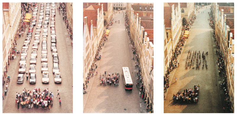
Sizable footprint? Sizable footprint!?!? The amount of space a bike sharing kiosk needs to operate is tiny, infinitesimal compared to the amount of space needed for car storage or public transit storage.

A picture makes my point most efficiently:


Moving people efficiently, adding capacity efficiently, reducing pollution, increasing exercise, I could go on: does not come with cars. Complaining that bikes have a sizable footprint while cars are somehow so unquestioned, so taken for granted as permanent fixtures that their impact goes unmentioned is willfully ignorant.

November 14, 2010

Building Coalitions for Better Streets, One School at a Time

Spaces that need improvements for bicycle and pedestrian users face a number of obstacles.

First: the land use patterns that make walking and biking more difficult than driving. This is the foundation, and it both politely and actively discourages users from reimagining the space as anything but autocentric.

Second: the lack of a visible group of beneficiaries. In the suburbs, people see cars, trucks, and more cars--why divert precious funds from what is clearly the dominant mode? Thus, projects for bikes and peds catch flak for wasting taxpayer dollars on frivolous expenditures. See anti Measure O arguments, short-sighted local business owners, and recent shift toward Republican leadership.

Third, is the lack of an organized group of beneficiaries. In most communities, stakeholders with significant buy-in to status quo arrangements--auto commuters in traffic, businesses with limited parking--will be the most vocal in calling for remedies. Conservative Taxpayer groups, business associations, and people fed up with commutes exert pressure on elected and appointed officials to keep expanding and improving roads and parking. There's a mobilized constituency for officials to work with. Outside of San Francisco, Portland, Seattle, and a handful of other places, Bike Coalitions are small players, and organizations angling for ped improvements are usually regional, national, or of the observational nature, like this blog. (This is from my limited experience, i.e., Complete Streets, Streetsblog, etc). In other words, they are less effective at building local constituencies.

In order to create demand for improved bike and ped infrastructure, one would need a constituency that cuts across economic and social class, is present in communities across the nation, and is intensely concerned about how local transportation networks serve pedestrians and bicyclists. A tall order--but the constituency exists: elementary and middle school students, their parents, and their teachers.

The Safe Routes to School (SRTS) initiative first popped up on the radar in the 1970s in the US and in the Netherlands. It only gathered momentum after 1997, when a local project in the Bronx gave rise to two nationally funded pilot programs. In 2005 and 2006, SAFETEA-LU, the massive federal transportation omnibus, appropriated $600 million to create the National Safe Routes to School Program, which has an excellent online guide for bringing a SRTS program to your school.

Since then, some 10,000 schools have received SRTS funding to improve the safety and convenience of pedestrian and bicycle infrastructure. The comprehensive online guide facilitates grass roots organizing by outlining sequential best practices for SRTS success--everything from how to build a coalition, to how to look for funding, to what a bump out and a chicane are, to how to improve street connectivity with retrofitted pedestrian access paths.
Suburban culs de-sac create inefficiencies and concentrate traffic on arterials

Now, I'm not suggesting that folks like myself pose as concerned parents and infiltrate PTAs to set up SRTS coalitions--though that would be fun--but there are organizations doing excellent work to organize communities of parents and educators, and link them with the funding and impetus to invest in reclaiming streets for school children. One of these is TransForm, based in Oakland. In 2008, it partnered with the Alameda County Transportation Improvement Authority to bring $1 million in SRTS funding to four Oakland schools:

This project is designed to remedy concerns frequently raised by parents, principals and students that speeding traffic poses safety issues and discourages walking and bicycling.  The project will include ADA-compliant pedestrian “bulb-outs” and ramps, crosswalks, pushbuttons and countdown signals, closes gaps and widens sidewalks at identified locations. Bicycling safety will be improved by adding new bike lanes on Alcatraz Avenue from Dover Street to College Avenue. The project also realigns traffic lanes on Hopkins Place to improve safety for vehicular traffic, as well as students walking or bicycling to school. Hopkins Place connects MacArthur Boulevard bicycle lanes with the front of Bret Harte Middle School.
The byproduct of mobilized school communities is a better infrastructure for the entire city, and ingrained good habits in its youth. Just like the Americans with Disabilities Act mandated curb cuts that are more frequently used by parents pushing strollers, or seniors pulling groceries, SRTS infrastructure improvements will all users to move around their environment in more ways, more safely and conveiently. I don't have the space here to elaborate on the multitudinous benefits of biking and walking to school (or anywhere else) from a social justice standpoint, so I'll just say that any reduction of automobile dependence anywhere will save money and lives. And that can only be a good thing.

Links:

SRTS projects in CA that received funding in the '10-11 funding year
TransForm info sheet for SRTS services they coordinate
SRTS program brief for 2010 (pdf)
More detailed ways to improve the school zone, the school route, street crossings, and traffic conditions.

November 13, 2010

Cars --> Bike Paths --> Greenways

Great new video up on StreetFilms about the work Portland has done to make city streets more bike friendly, and the work Portland is doing to move beyond bike paths and sharrows to a more holistic "greenway."


Design touches of note are the way city planners have used curb extensions and road medians to create stormwater treatments sites. The idea is to prevent rainwater--which carries oil residues and particles from brake pads, tires, etc--from draining directly into creeks and streams. Instead, a median has a planted bed flush with the asphalt surrounding it, and the curb border has strategic cuts to allow in the rainwater. A mix of hardy native plants able to withstand some heavy metals, and layers of soil, sand, and gravel filter the water as it re-enters aquifers and groundwater supplies--rather than flow directly into the local creek or stream. Depending on the watershed, aquifers will recharge streams, or streams will recharge aquifers, though usually there's some sort of dynamic equilibrium.


Now: I think Oakland should be taking notes. The residential blocks for lots of Oakland look similar to areas in the Portland video above, additionally, Oakland has a large population segment that would benefit from a reduction in automobile dependency. From a social justice point of view, biking would mitigate pollution, obesity, and the cost of transit and car ownership. Granted, much pollution comes from trucks and boats bound for the port, and from highways precariously close to dwellings, but still--a move in the right direction. The median project would be a great way to add more green into a chronically gray city. Medians also create pedestrian refuges, which would make MLK Blvd, Shattuck, and Telegraph much easier to cross.

Getting all of this going would require a robust bicycle education component to accompany any infrastructure improvements. K-12 collaboration with parents and city leaders, the works. More on that topic in a future post.

October 21, 2010

More Bike Updates, East Bay Style

First, the East Bay Regional Park District has been awarded a $10 million grant to connect gaps in its bicycle and ped path network. Funding comes from the Federal Tiger grant program. Iron Horse trail, my local standby, gets some southern extensions to link up with the Dublin/Pleasanton BART and the new developments around there. The map of the planned improvements was a little lo-res even before I took a screen capture, so your best bet is to follow the link above.

Second, Oakland has some plans of its own: a bikeway that will flow, mas o menos, along the 53rd street corridor from Emeryville to the Rockridge BART station. It will add capacity as an east-west connector that complements existing bikeways: 65th/Ashby BART/Woolsey to the North, and 40th Street/MacArthur BART to the south.


The area under evaluation is between those little orange boxes. Oakland's study proposed a number of alignments, which are visible on the map below:


The final alignment selected, near as I can tell from the city report (Scribd doc @ the end), is #3.

I was pleasantly reading the careful thought the planners had invested in the project--finding funding, sending mailers to residents of 53rd street, compiling feedback from myriad sources, discussing the +/-'s of the 6 different alignments--when I realized that this is all just to paint sharrows. Wtf? Do they really need all that work just to paint some white bike stencils+chevrons? There will be bike-signage as well, with little bike symbols and city and BART directionals, but yeesh.

I also wonder if the addition of sharrows actually does anything--I'd be hard pressed to describe biking on a street with sharrows as any more inviting than biking on a street without them.

The real reason why more significant bike infrastructure (a proper bike lane) is MIA is probably that the streets are too narrow to stripe two five-foot bike lanes while retaining a lane of parking on both sides AND two way travel lanes. Since I'm not intimately familiar with the streets in question, I can't speak to the kind of traffic they get, or the speed. On many residential streets a bike lane is redundant; its principal use is for carving a safe travelway out of busier, car-heavier roads.

So maybe a full bike lane would be overkill after all, but the question about whether public meetings and planning documents and alignment examinations are necessary for sharrow painting remains. It seems the City needs to cover its bases, make sure the residents know to expect some increases in bike traffic, and make sure it has documentation showing careful deliberations were made. No wonder funding is an issue.

October 20, 2010

San Francisco Bike Plan

Wow. Streetsblog has the details, I'm just going to post some pictures for visual pizazz. Dedicated bike lanes, solid green lanes, mode split goal of 20%, making biking safe for ages "8 to 80", a new waterfront bike path, even neato Scandinavian tools for scaling hills. All from the San Francisco Bike Coalition, priced at $100 million. No funding or official SFMTA sign-ons yet.

Connecting the City's proposed three priority crosstown routes. Map: Jack Reinick for SFBC.

A draft network of 128 miles of bikeways in the city. Image: SFBC. (Click to enlarge).

October 14, 2010

Suburban Biking

Cool scoop from Cyclelicio.us: East Bay City Experiments with traffic light radar detection for bicycles.

Part of me wants to say that radar detection for bikes at intersections seems like readying the cherries for your sundae when maybe you should see about getting a bowl for the ice cream. You know, practical infrastructure: the bike lanes, separated bikeways, and bike parking playing the metaphorical bowl.

The other part of me knows a good thing when I see it. Acknowledging that bikes have a right to be on the road by incorporating them into the system hardware--yes, good, and hopefully this has the positive feedback effect (once/if the Pleasanton project is scaled up) of mainstreaming bike culture, and encouraging new users.

September 12, 2010

Quick hit: Bike parking

Leave it to the Japanese to find a compact way to store hundreds of bicycles. From what I've read, this is just in Tokyo for now, though the vid says the company is looking to expand to other metropolitan areas.